File:Mapa de los Estados Unidos de Colombia (1864).jpg
.jpg&redirect=no)

Original file (3,660 × 2,974 pixels, file size: 2.89 MB, MIME type: image/jpeg)
Captions
Captions
Summary edit
.jpg&action=edit§ion=1)
| Description |
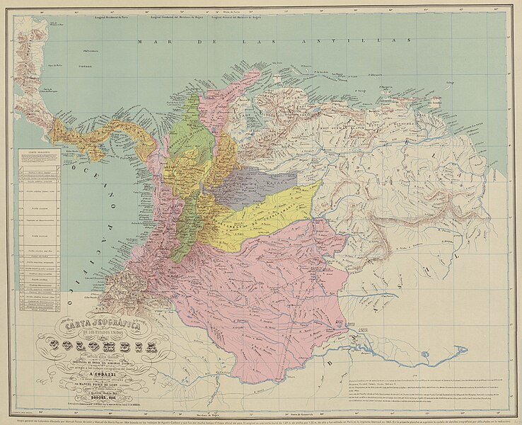
Español: Carta Jeográfica de los Estados Unidos de Colombia. Tomado del "Atlas geográfico e histórico de la República de Colombia", 1890 y el "Atlas de Colombia", 1967 |
||||
| Date | |||||
| Source |
Atlas geográfico e histórico de la República de Colombia, 1890 http://www.lablaa.org/blaavirtual/faunayflora/orinoco/orinoco9a.htm http://www.revistacredencial.com/credencial_historia/atlas/home_atlas.htm |
||||
| Author | Agustín Codazzi, Manuel Maria Paz, Felipe Pérez | ||||
| Permission (Reusing this file) |
|
||||
File history
Click on a date/time to view the file as it appeared at that time.
| Date/Time | Thumbnail | Dimensions | User | Comment | |
|---|---|---|---|---|---|
| current | 06:14, 1 May 2021 | | 3,660 × 2,974 (2.89 MB) | Milenioscuro (talk | contribs) | resolución |
| 20:59, 10 January 2011 |  | 720 × 560 (145 KB) | Milenioscuro (talk | contribs) | mapa con mejores colores y mas nitido | |
| 05:01, 27 October 2010 |  | 591 × 473 (57 KB) | Milenioscuro (talk | contribs) | Reverted to version as of 17:24, 5 August 2008 | |
| 01:48, 5 April 2010 |  | 582 × 450 (224 KB) | Milenioscuro (talk | contribs) | mapa con mejor resolución | |
| 17:24, 5 August 2008 |  | 591 × 473 (57 KB) | Milenioscuro (talk | contribs) | {{Information |Description={{es|1=Estados Unidos de Colombia. Tomado del "Atlas histórico y geográfico de Colombia", 1890.}} |Source=http://www.lablaa.org/blaavirtual/faunayflora/orinoco/orinoco9a.htm |Author=Agustin Codazzi |Date=1890 |Permission= |oth |
You cannot overwrite this file.
File usage on Commons
The following 2 pages use this file:
File usage on other wikis
The following other wikis use this file:
- Usage on de.wikisource.org
- Usage on el.wikipedia.org
- Usage on en.wikipedia.org
- Usage on es.wikipedia.org
- Usage on fr.wikipedia.org
- Usage on id.wikipedia.org
- Usage on it.wikipedia.org
- Usage on pt.wikipedia.org
- Usage on tr.wikipedia.org
.jpg&oldid=818867681)