File:Mapa físico de localización Tarija.svg

Size of this PNG preview of this SVG file: 512 × 325 pixels. Other resolutions: 320 × 203 pixels | 640 × 406 pixels | 1,024 × 650 pixels | 1,280 × 813 pixels | 2,560 × 1,625 pixels.
Original file (SVG file, nominally 512 × 325 pixels, file size: 7.23 MB)
Captions
Captions
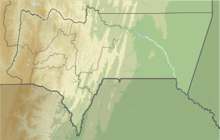
Physical map of Tarija.
Summary
edit| Description |
Español: Mapa físico de localización del departamento de Tarija. Parámetros de proyección equirectangular de File:Mapa de localización Tarija.svg. |
| Date | |
| Source |
Own work using:
|
| Author | Waterloo1883 |
| Other versions |
|

Licensing
edit
I, the copyright holder of this work, hereby publish it under the following license:
This file is licensed under the Creative Commons Attribution-Share Alike 4.0 International license.
- You are free:
- to share – to copy, distribute and transmit the work
- to remix – to adapt the work
- Under the following conditions:
- attribution – You must give appropriate credit, provide a link to the license, and indicate if changes were made. You may do so in any reasonable manner, but not in any way that suggests the licensor endorses you or your use.
- share alike – If you remix, transform, or build upon the material, you must distribute your contributions under the same or compatible license as the original.
File history
Click on a date/time to view the file as it appeared at that time.
| Date/Time | Thumbnail | Dimensions | User | Comment | |
|---|---|---|---|---|---|
| current | 02:40, 13 December 2020 | | 512 × 325 (7.23 MB) | Waterloo1883 (talk | contribs) | Uploaded own work with UploadWizard |
You cannot overwrite this file.
File usage on Commons
The following 2 pages use this file:
File usage on other wikis
The following other wikis use this file:
- Usage on es.wikipedia.org
- Usage on fr.wikipedia.org