File:Mapa geographica completens Indiae Occidentalis.jpg

Original file (3,102 × 3,677 pixels, file size: 3.18 MB, MIME type: image/jpeg)
Captions
Captions
Summary edit
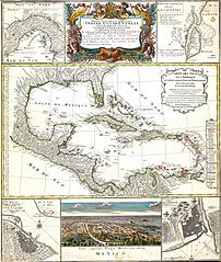
| Map title | Mapa geographica completens Indiae Occidentalis |
| Description | Includes d'Anville's Carte des Isles de Amerique. |
| Creator | Homann, Johann Baptist |
| Contributor | PALMM Project |
| Date | 1737 |
| Rights Information | Electronic version created 2003 as part of the Florida Map Collection project. |
Licensing edit
|
This work is in the public domain in its country of origin and other countries and areas where the copyright term is the author's life plus 70 years or fewer.
| |
| This file has been identified as being free of known restrictions under copyright law, including all related and neighboring rights. | |
File history
Click on a date/time to view the file as it appeared at that time.
| Date/Time | Thumbnail | Dimensions | User | Comment | |
|---|---|---|---|---|---|
| current | 20:52, 16 January 2005 | | 3,102 × 3,677 (3.18 MB) | ¡0-8-15! (talk | contribs) | {{PD}} |
You cannot overwrite this file.
File usage on Commons
The following 4 pages use this file:
File usage on other wikis
The following other wikis use this file:
- Usage on es.wikipedia.org