File:Mapanuepe Lake-before & after.gif

Size of this preview: 388 × 599 pixels. Other resolutions: 155 × 240 pixels | 500 × 772 pixels.
Original file (500 × 772 pixels, file size: 90 KB, MIME type: image/gif)
Captions
Captions
Add a one-line explanation of what this file represents
Summary edit
| Description |
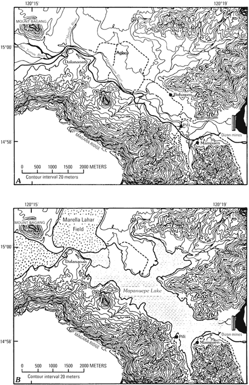
English: The map of Mapanuepe Valley before the eruption of Mount Pinatubo and after the lake has formed. |
| Date | |
| Source | http://pubs.usgs.gov/pinatubo/umbal/fig16.gif |
| Author | U.S. Geological Survey |
| Permission (Reusing this file) |
Work by U.S. Government. |
Licensing edit
This image is in the public domain in the United States because it only contains materials that originally came from the United States Geological Survey, an agency of the United States Department of the Interior. For more information, see the official USGS copyright policy.
|
File history
Click on a date/time to view the file as it appeared at that time.
| Date/Time | Thumbnail | Dimensions | User | Comment | |
|---|---|---|---|---|---|
| current | 20:20, 17 June 2011 | | 500 × 772 (90 KB) | Briarfallen (talk | contribs) | {{Information |Description ={{en|1=The map of Mapanuepe Valley before the eruption of Mount Pinatubo and after the lake has formed. }} |Source =http://pubs.usgs.gov/pinatubo/umbal/fig16.gif |Author =U.S. Geological Survey |Date |
You cannot overwrite this file.
File usage on Commons
The following page uses this file:
File usage on other wikis
The following other wikis use this file:
- Usage on en.wikipedia.org
- Usage on ilo.wikipedia.org