File:Maps of Ezo, Sakhalin, and Kuril Islands WDL3.png

Size of this preview: 412 × 599 pixels. Other resolutions: 165 × 240 pixels | 330 × 480 pixels | 528 × 768 pixels | 1,024 × 1,488 pixels.
Original file (1,024 × 1,488 pixels, file size: 2.26 MB, MIME type: image/png)
File information
Structured data
Captions
Captions
Add a one-line explanation of what this file represents
Summary edit
| Author |
Русский: Фуджита, Тонзай
Français : Fujita, Tonsai
English: Fujita, Tonsai
中文:藤田, 通赛
Português: Fujita, Tonsai
العربية: فوجيتا, تونساي
Español: Fujita, Tonsai |
| Title |
Русский: Карты Эдзо, Сахалина и Курильских островов
Français : Cartes d’Ezo, de Sakhaline et des îles Kouriles
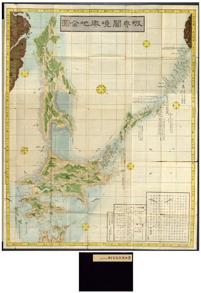
English: Maps of Ezo, Sakhalin, and Kuril Islands
中文:虾夷、库页岛和千岛群岛的地图
Português: Mapas das ilhas de Ezo, Sacalina e Kuril
العربية: خرائط جزر إيزو، وساخالين، وكوريل
Español: Mapas de las Islas Ezo, de Sajalín, y Kuriles |
| Description |
Русский: Эта карта была составлена Фуджита Хунсай и издана Харимайа Катсугоро в 1854 году, приблизительно в тот период времени, когда сёгунат Токугава начал отправлять экспедиции в район Эзо, Сахалина и Курильских островов. В это время Россия также проявляла интерес к данному региону. Географические названия приведены на японском языке и написаны при помощи иероглифов катакана (японское угловое фонетическое слоговое письмо). Приводится подробное изображение различных сухопутных и морских маршрутов в регионе Эзо (ныне Хоккайдо).
Français : Cette carte a été dessinée par Fujita Junsai et publiée par Harimaya Katsugorō en 1854, vers la période à laquelle le shogunat des Tokugawa a commencé à envoyer des expéditions dans la région d’Ezo, de Sakhaline et des îles Kouriles. La Russie manifestait également son intérêt pour cette région à cette époque. Les noms de lieux sont identifiés et indiqués en caractères japonais katakana (le syllabaire phonétique japonais anguleux). Plusieurs routes terrestres et maritimes de la région d’Ezo (aujourd'hui Hokkaido) apparaissent en détail.
English: This map was made by Fujita Junsai and published by Harimaya Katsugorō in 1854, around the time period when the Tokugawa shogunate started sending expeditions to the area of Ezo, Sakhalin, and the Kuril Islands. Russia was also showing interest in this area at this time. Place names are identified and indicated in the Japanese katakana characters (the angular Japanese phonetic syllabary). Various land and sea routes in the Ezo area (now Hokkaido) are shown in detail.
中文:这幅地图是由 Fujita Junsai 绘制,1854 年由 Harimaya Katsugorō 负责出版。在此时期德川幕府开始向虾夷、库页岛和千岛群岛地区派遣考察队。 当时的俄罗斯也对这些地区存在兴趣。 这些地名具有明显的日本片假名特征(生硬的日本发音音节)。 该地图详细反应了虾夷地区(现在的北海道)的众多陆地和海洋路线。
Português: Este mapa foi feito por Fujita Junsai e publicado por Harimaya Katsugorō em 1854, por volta do período em que o Xogunato de Tokugawa começou a enviar expedições para a área das ilhas de Ezo, Sacalina e Kuril. Na época, a Rússia estava, também, mostrando interesse por esta área. Os nomes de lugares são identificados e indicados nos caracteres katakana japoneses (o silabário fonético angular japonês). Várias rotas terrestres e marítimas na área de Ezo (hoje Hokkaido) são mostradas em detalhes.
العربية: رسم هذه الخريطة فوجيتا جونساي ونشرها هاريمايا كاتسوغورو في 1854، أثناء الفترة التي باشر فيها نظام الشوغون الاوكوغاوي بإرسال البعثات إلى منطقة إيزو، ساخالين، ودزر الكوريل. كما أن روسيا كانت أيضا تبدي اهتماما في هذه المنطقة آنذاك. وتبدو أسماء الأماكن محددة ومبينة في أحرف الكاتاكانا اليابانية (الكتلبة المقطعية الصوتية الزاوية). وتظهر الطرق البرية والبحرية في منطقة إيزو (هوكايدو حاليا) بالتفصيل.
Español: Este mapa fue elaborado por Fujita Junsai y publicado por Harimaya Katsugorō en 1854, en el período en que el shogunato Tokugawa empezó a enviar expediciones al área de Ezo, Sajalín y las Islas Kuriles. En esta época, Rusia también mostraba interés en esa zona. Los nombres geográficos están identificados e indicados usando los caracteres katakana japoneses (el silabario fonético angular japonés). Se muestran en detalle varias rutas terrestres y marítimas del área de Ezo (actualmente Hokkaido). |
| Date |
1854 date QS:P571,+1854-00-00T00:00:00Z/9 |
| Medium |
Русский: Карты
Français : Cartes
English: Maps
中文:地图
Português: Mapas
العربية: خرائط
Español: Mapas |
| Dimensions |
English: 1 color map, 115 x 92 centimeters, folded in cover in case 26 x 19 centimeters |
| Collection |
Русский: Библиотека Конгресса
Français : Bibliothèque du Congrès
English: Library of Congress
中文:国会图书馆
Português: Biblioteca do Congresso
العربية: مكتبة الكونغرس
Español: Biblioteca del Congreso |
| Place of creation |
Русский: Хоккайдо
Français : Hokkaido
English: Hokkaido
中文:北海道
Português: Hokkaido
العربية: هوكايدو
Español: Hokkaido |
| Notes | Original language title: 蝦夷闔境輿地全図 |
| References | http://hdl.loc.gov/loc.wdl/dlc.3 |
| Source/Photographer |
|
Licensing edit
|
This is a faithful photographic reproduction of a two-dimensional, public domain work of art. The work of art itself is in the public domain for the following reason:
The official position taken by the Wikimedia Foundation is that "faithful reproductions of two-dimensional public domain works of art are public domain".
This photographic reproduction is therefore also considered to be in the public domain in the United States. In other jurisdictions, re-use of this content may be restricted; see Reuse of PD-Art photographs for details. | |||||
File history
Click on a date/time to view the file as it appeared at that time.
| Date/Time | Thumbnail | Dimensions | User | Comment | |
|---|---|---|---|---|---|
| current | 13:42, 11 March 2014 |  | 1,024 × 1,488 (2.26 MB) | Fæ (talk | contribs) | =={{int:filedesc}}== {{Artwork |artist = |author ={{ru|1=Фуджита, Тонзай}} {{fr|1=Fujita, Tonsai}} {{en|1=Fujita, Tonsai}} {{zh|1=藤田, 通赛}} {{pt|1=Fujita, Tonsai}} {{ar|1=فوجيتا, تونساي}} {{es|1=Fujita, Tonsai}} |title... |
You cannot overwrite this file.
File usage on Commons
The following page uses this file: