File:Maps of Lawrence County, S.D. mines LOC 2012593673.jpg

Size of this preview: 666 × 599 pixels. Other resolutions: 267 × 240 pixels | 534 × 480 pixels | 854 × 768 pixels | 1,138 × 1,024 pixels | 2,276 × 2,048 pixels | 15,332 × 13,795 pixels.
Original file (15,332 × 13,795 pixels, file size: 25.87 MB, MIME type: image/jpeg)
Captions
Captions
Add a one-line explanation of what this file represents
Summary
edit| Warning | The original file is very high-resolution. It might not load properly or could cause your browser to freeze when opened at full size. |
|---|
| Description |
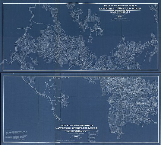
English: Relief shown by hachures. Cadastral map showing mining and mill sites and some landowners' names, roads, railroads, etc. Blueprint. Map printed in 2 segments on 2 sheets. LC copy imperfect: Part of lower edge torn. Includes note. Available also through the Library of Congress Web site as a raster image. |
||
| Title | Maps of Lawrence County, S.D. mines | ||
| Shelf ID | G4183.L3H1 1897 .R6 | ||
| Date | |||
| Source | https://www.loc.gov/item/2012593673/ | ||
| Author | Robinson, Edward J. | ||
| Permission (Reusing this file) |
|
||
| Location | Lawrence County · United States · South Dakota | ||
| Part of | American Memory · Catalog · County Landownership Maps · Geography And Map Division · Cultural Landscapes | ||
| Subject | Cadastral Maps · South Dakota · Geological Maps · Mines And Mineral Resources · United States · Maps · Lawrence County · Real Property · Landowners |

Licensing
edit
|
This is a faithful photographic reproduction of a two-dimensional, public domain work of art. The work of art itself is in the public domain for the following reason:
The official position taken by the Wikimedia Foundation is that "faithful reproductions of two-dimensional public domain works of art are public domain".
This photographic reproduction is therefore also considered to be in the public domain in the United States. In other jurisdictions, re-use of this content may be restricted; see Reuse of PD-Art photographs for details. | ||||
File history
Click on a date/time to view the file as it appeared at that time.
| Date/Time | Thumbnail | Dimensions | User | Comment | |
|---|---|---|---|---|---|
| current | 10:05, 15 May 2018 | | 15,332 × 13,795 (25.87 MB) | Fæ (talk | contribs) | LOC Maps https://www.loc.gov/item/2012593673/ #8857 |
You cannot overwrite this file.
File usage on Commons
There are no pages that use this file.