File:Mariana trench location.jpg
No higher resolution available.
Mariana_trench_location.jpg (400 × 400 pixels, file size: 59 KB, MIME type: image/jpeg)
Captions
Captions
Add a one-line explanation of what this file represents

|
This locator map image could be re-created using vector graphics as an SVG file. This has several advantages; see Commons:Media for cleanup for more information. If an SVG form of this image is available, please upload it and afterwards replace this template with
{{vector version available|new image name}}.
It is recommended to name the SVG file “Mariana trench location.svg”—then the template Vector version available (or Vva) does not need the new image name parameter. |

Summary edit
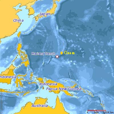
The image is copied from the article entitled Mariana Trench in the "English Wikipedia." It is generated by the User Dcfleck at www.planiglobe.com with the licensing, accroding to the original source, as follows.
Licensing edit
This file is licensed under the Creative Commons Attribution 2.5 Generic license.
- You are free:
- to share – to copy, distribute and transmit the work
- to remix – to adapt the work
- Under the following conditions:
- attribution – You must give appropriate credit, provide a link to the license, and indicate if changes were made. You may do so in any reasonable manner, but not in any way that suggests the licensor endorses you or your use.
Planiglobe license:
| This image is from Planiglobe. All maps hosted on Planiglobe are licensed under the Creative Commons Attribution 2.5 License, but Planiglobe suggests that they not be used for navigational purposes. For the purposes of this license, this clause is considered a disclaimer and not a license restriction. This file is licensed under the Creative Commons Attribution 2.5 Generic license.
|
File history
Click on a date/time to view the file as it appeared at that time.
| Date/Time | Thumbnail | Dimensions | User | Comment | |
|---|---|---|---|---|---|
| current | 09:00, 24 July 2014 | | 400 × 400 (59 KB) | Bryan Hwang (talk | contribs) | Add the location of Guam. |
| 18:49, 30 January 2006 |  | 400 × 400 (31 KB) | Hypokeimenon~commonswiki (talk | contribs) | The image is copied from the "English Wikipedia," which is enerated by {{User|Dcfleck}} at [http://www.planiglobe.com www.planiglobe.com] with the licensing, accroding to the original source, as follows. == Licensing == {{cc-by-2.5}} |
You cannot overwrite this file.
File usage on Commons
The following 2 pages use this file:
File usage on other wikis
The following other wikis use this file:
- Usage on ba.wikipedia.org
- Usage on bg.wikipedia.org
- Usage on bn.wikipedia.org
- Usage on br.wikipedia.org
- Usage on en.wikipedia.org
- Usage on es.wikipedia.org
- Usage on et.wikipedia.org
- Usage on id.wikipedia.org
- Usage on ja.wikipedia.org
- Usage on jv.wikipedia.org
- Usage on mn.wikipedia.org
- Usage on pl.wikipedia.org
- Usage on sl.wikipedia.org
- Usage on tg.wikipedia.org
- Usage on th.wikipedia.org
- Usage on tr.wikipedia.org
- Usage on tt.wikipedia.org
- Usage on uk.wikipedia.org
- Usage on www.wikidata.org
- Usage on zh-classical.wikipedia.org
- Usage on zh.wikipedia.org