File:MarktRoßtal Karte.svg

Size of this PNG preview of this SVG file: 560 × 420 pixels. Other resolutions: 320 × 240 pixels | 640 × 480 pixels | 1,024 × 768 pixels | 1,280 × 960 pixels | 2,560 × 1,920 pixels.
Original file (SVG file, nominally 560 × 420 pixels, file size: 80 KB)
Captions
Captions
Add a one-line explanation of what this file represents
Summary edit
| Description |
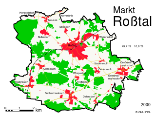
map of the market town Roßtal Deutsch: Karte des Markt Roßtal
Dargestellt sind bebaute Flächen, Wälder und Verkehrswege in schematischer Farbdarstellung. Maßstab 50px/km in der Standardgröße |
| Date | |
| Source | Own work |
| Author | Geek3 |
W3C-validity not checked.
Licensing edit
I, the copyright holder of this work, hereby publish it under the following licenses:
This file is licensed under the Creative Commons Attribution-Share Alike 3.0 Unported license.
- You are free:
- to share – to copy, distribute and transmit the work
- to remix – to adapt the work
- Under the following conditions:
- attribution – You must give appropriate credit, provide a link to the license, and indicate if changes were made. You may do so in any reasonable manner, but not in any way that suggests the licensor endorses you or your use.
- share alike – If you remix, transform, or build upon the material, you must distribute your contributions under the same or compatible license as the original.

|
Permission is granted to copy, distribute and/or modify this document under the terms of the GNU Free Documentation License, Version 1.2 or any later version published by the Free Software Foundation; with no Invariant Sections, no Front-Cover Texts, and no Back-Cover Texts. A copy of the license is included in the section entitled GNU Free Documentation License. |
You may select the license of your choice.
File history
Click on a date/time to view the file as it appeared at that time.
| Date/Time | Thumbnail | Dimensions | User | Comment | |
|---|---|---|---|---|---|
| current | 18:08, 17 July 2008 | | 560 × 420 (80 KB) | Geek3 (talk | contribs) | {{Information |Description=map of the market town Roßtal {{de|1=Karte des Markt Roßtal Dargestellt sind bebaute Flächen, Wälder und Verkehrswege in schematischer Farbdarstellung. Maßstab 50px/km in der Standardgröße}} |Source=Own work by uploader |
You cannot overwrite this file.
File usage on Commons
There are no pages that use this file.
File usage on other wikis
The following other wikis use this file:
- Usage on ja.wikipedia.org