File:Marlborough Sounds, New Zealand.jpg
Size of this preview: 800 × 600 pixels. Other resolutions: 320 × 240 pixels | 640 × 480 pixels | 1,024 × 768 pixels | 1,280 × 960 pixels | 2,560 × 1,920 pixels | 4,096 × 3,072 pixels.
Original file (4,096 × 3,072 pixels, file size: 12.37 MB, MIME type: image/jpeg)
Captions
Captions
Add a one-line explanation of what this file represents
Summary
edit
| Description |
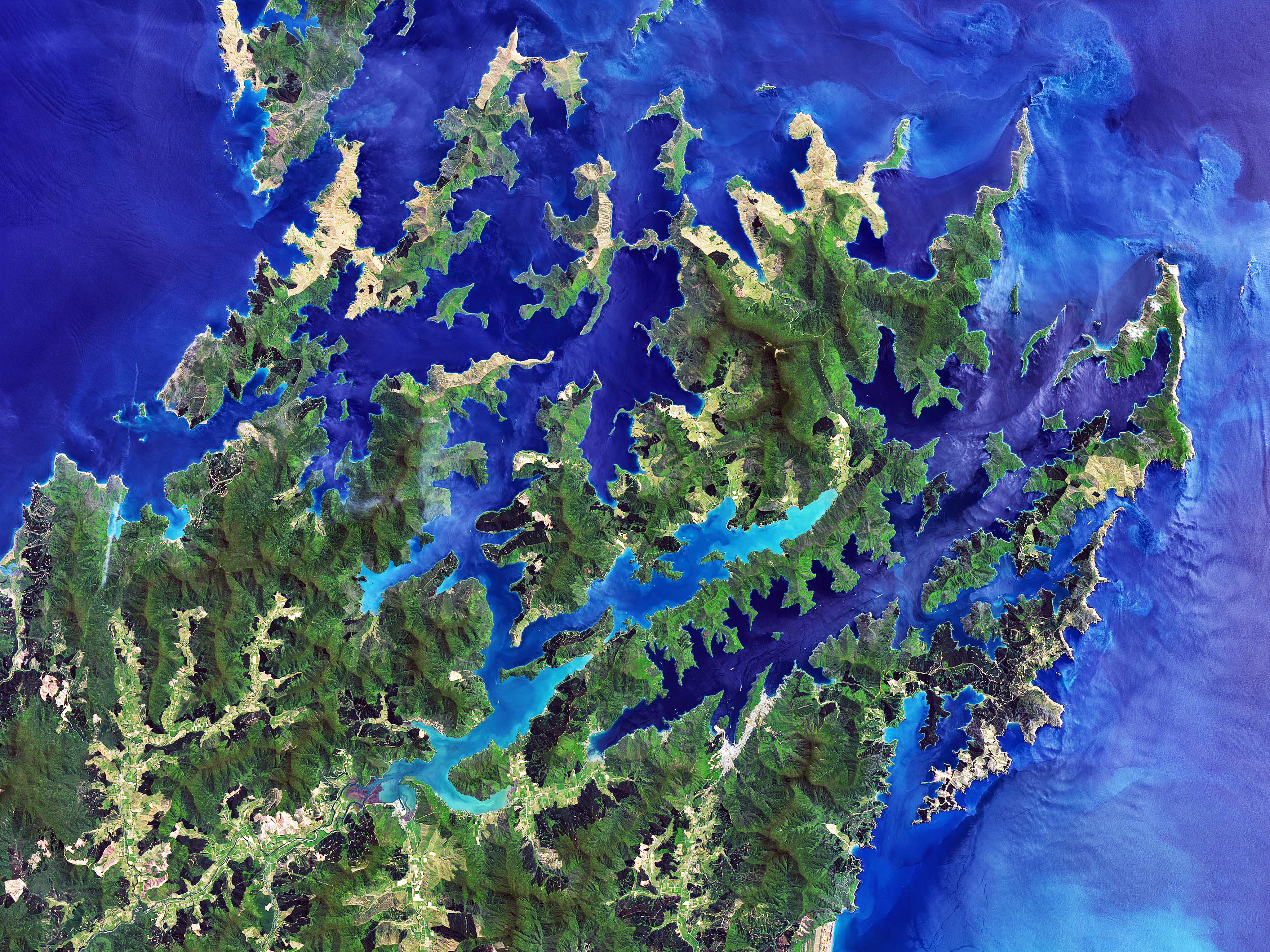
English: Marlborough Sounds, South Island, New Zealand |
| Date | |
| Source | https://eoimages.gsfc.nasa.gov/images/imagerecords/91000/91668/newzealand_oli_2017336_lrg.jpg |
| Author | Satellite image from Operational Land Imager (OLI) on Landsat 8 |
| Permission (Reusing this file) |
https://earthobservatory.nasa.gov/ImageUse/ |
Licensing
edit
| This file is in the public domain in the United States because it was solely created by NASA. NASA copyright policy states that "NASA material is not protected by copyright unless noted". (See Template:PD-USGov, NASA copyright policy page or JPL Image Use Policy.) | ||
 |
Warnings:
|
File history
Click on a date/time to view the file as it appeared at that time.
| Date/Time | Thumbnail | Dimensions | User | Comment | |
|---|---|---|---|---|---|
| current | 07:50, 15 March 2018 | | 4,096 × 3,072 (12.37 MB) | Ulanwp (talk | contribs) | {{Information |description ={{en|1=Marlborough Sounds, South Island, New Zealand}} |source =https://eoimages.gsfc.nasa.gov/images/imagerecords/91000/91668/newzealand_oli_2017336_lrg.jpg |author =Satellite image from Operational Land Imager (OLI) on Landsat 8 |date =2017-12-02 |permission =https://earthobservatory.nasa.gov/ImageUse/ }} Category:Marlborough Sounds |
You cannot overwrite this file.
File usage on Commons
There are no pages that use this file.
File usage on other wikis
The following other wikis use this file:
- Usage on de.wikipedia.org
- Usage on es.wikipedia.org
- Usage on fr.wikipedia.org
- Île d'Urville (Nouvelle-Zélande)
- The Brothers (Nouvelle-Zélande)
- Île de Maud
- Marlborough Sounds
- Tinline (rivière)
- Île Stephens
- French Pass
- Île Blumine
- Wikipédia:Wikiconcours/mars 2022/Équipes
- Baie de Pelorus
- Wikipédia:Wikiconcours/mars 2022/Équipes/Équipe 18
- Baie de Tōtaranui
- Baie de Kenepuru
- Mont Stokes
- Île Arapaoa
- Canal de Tory
- Baie de Tennyson
- Te Whanganui
- Croisilles Harbour
- Baie de l'Amirauté (Nouvelle-Zélande)
- Île Matapara
- Cap Soucis
- Modèle:Palette Marlborough Sounds
- Île Motuara
- Long Island (Marlborough)
- Baie Anakoha
- Île Forsyth
- Îles Chetwode
- Usage on it.wikipedia.org