File:Marlton circle.jpg

Size of this preview: 800 × 600 pixels. Other resolutions: 320 × 240 pixels | 640 × 480 pixels | 1,024 × 768 pixels | 1,280 × 960 pixels | 2,048 × 1,536 pixels.
Original file (2,048 × 1,536 pixels, file size: 746 KB, MIME type: image/jpeg)
Captions
Captions
Add a one-line explanation of what this file represents
Summary edit
| Description |
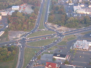
English: Marlton Circle, Evesham Township, New Jersey. The intersection of New Jersey State Highways 70 and 73. Taken from the West looking East at eight hundred feet above ground level from a Schweizer 269CB helicopter. Photographed on 17 October, 2007, at 5:43PM, EDT. Photographed by Nicholas Stolley. |
| Date | 17 October 2007 (according to Exif data) |
| Source | Own work |
| Author | User:Airplaneit |
Licensing edit
| This work has been released into the public domain by its author, Airplaneit. This applies worldwide. In some countries this may not be legally possible; if so: |
Original upload log edit
Transferred from en.wikipedia to Commons using For the Common Good.
The original description page was here. All following user names refer to en.wikipedia.
| Date/Time | Dimensions | User | Comment |
|---|---|---|---|
| 01:39, 18 October 2007 | 2,048 × 1,536 (763,988 bytes) | w:en:Airplaneit (talk | contribs) | (Marlton Circle, Evesham Township, New Jersey. Intersection of New Jersey State Highways 70 and 73. Taken from the Southwest looking Northeast at eight hundred feet above ground level from a Schweizer 269CB Helicopter. Photographed on 17 October, 2007, at ) |
File history
Click on a date/time to view the file as it appeared at that time.
| Date/Time | Thumbnail | Dimensions | User | Comment | |
|---|---|---|---|---|---|
| current | 03:51, 10 May 2013 | | 2,048 × 1,536 (746 KB) | Addihockey10 (talk | contribs) | Transferred from en.wikipedia: see original upload log above |
You cannot overwrite this file.
File usage on Commons
The following page uses this file:
File usage on other wikis
The following other wikis use this file:
- Usage on en.wikipedia.org
- Usage on fi.wikipedia.org