File:MarsCuriosityRover-MapToMountSharp-Sol0561-20140305.jpg

Size of this preview: 776 × 600 pixels. Other resolutions: 311 × 240 pixels | 621 × 480 pixels | 994 × 768 pixels | 1,280 × 989 pixels | 2,560 × 1,978 pixels | 3,300 × 2,550 pixels.
Original file (3,300 × 2,550 pixels, file size: 1.49 MB, MIME type: image/jpeg)
Captions
Captions
Add a one-line explanation of what this file represents
Summary edit
| Description |
English: 03.05.2014
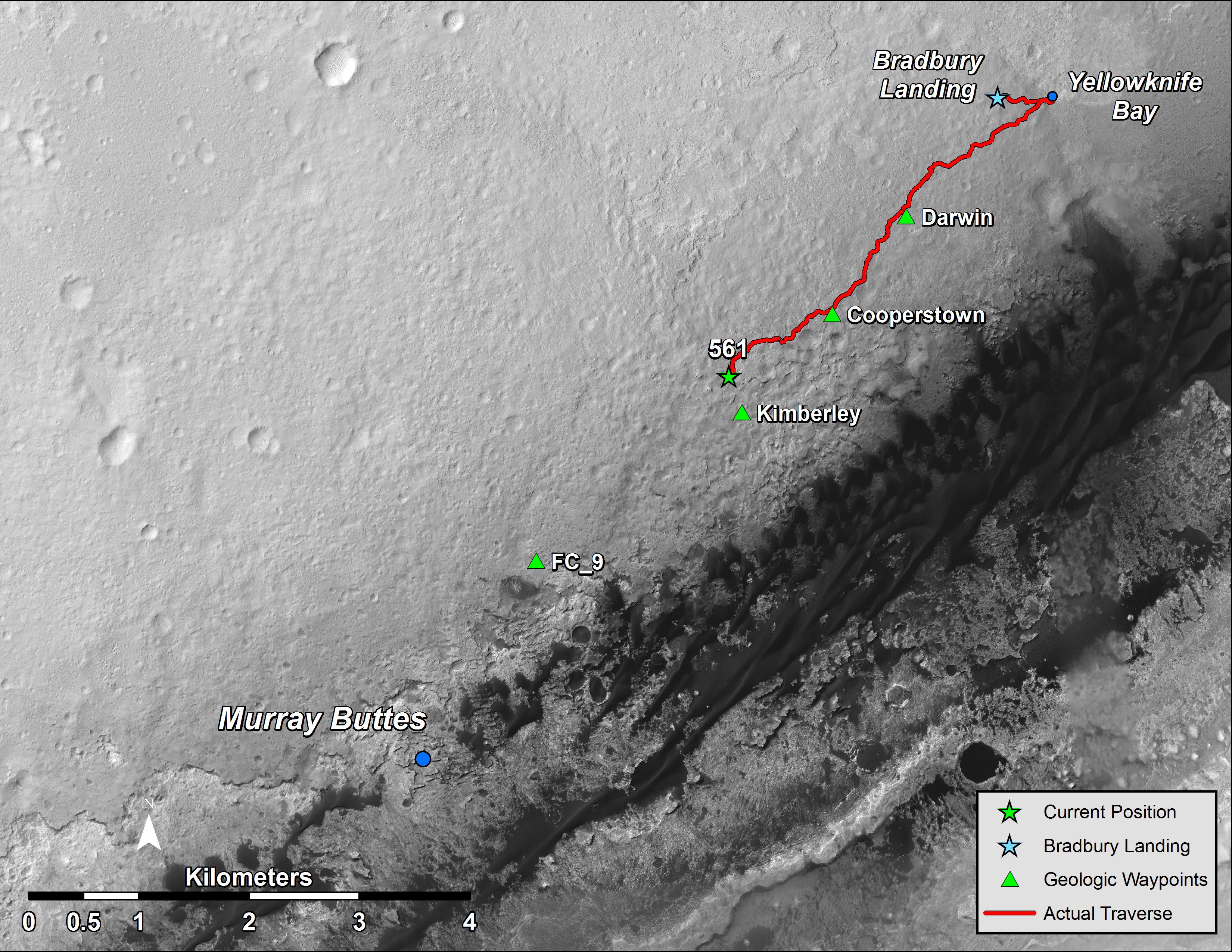
Big-Context Traverse Map Through Sol 561 http://mars.jpl.nasa.gov/msl/multimedia/images/?ImageID=6052 This map shows the route driven by NASA's Mars rover Curiosity through the 561st Martian day, or sol, of the rover's mission on Mars (March 5, 2014). The location labeled 561 is the location of the rover after that sol's drive of about 100 feet (30.5 meters). Yellowknife Bay is where Curiosity found evidence for a habitable lakebed environment on ancient Mars. Murray Buttes is a possible entryway to the lower slopes of Mount Sharp, the mission's long-term destination. North is up. The scale bar is 4 kilometers (~2.5 miles). The base image from the map is from the High Resolution Imaging Science Experiment Camera (HiRISE) in NASA's Mars Reconnaissance Orbiter. |
| Date | |
| Source | http://mars.jpl.nasa.gov/msl/images/MSL_CurrentTraverse_to_MtSharp_sol0561_zoom-full.jpg |
| Author | NASA/JPL-Caltech/Univ. of Arizona |
Licensing edit
| This file is in the public domain in the United States because it was solely created by NASA. NASA copyright policy states that "NASA material is not protected by copyright unless noted". (See Template:PD-USGov, NASA copyright policy page or JPL Image Use Policy.) | ||
 |
Warnings:
|
File history
Click on a date/time to view the file as it appeared at that time.
| Date/Time | Thumbnail | Dimensions | User | Comment | |
|---|---|---|---|---|---|
| current | 23:11, 6 March 2014 | | 3,300 × 2,550 (1.49 MB) | Drbogdan (talk | contribs) | User created page with UploadWizard |
You cannot overwrite this file.
File usage on Commons
The following page uses this file: