File:Marsh Lane "Narrows", near Wolverhampton - geograph.org.uk - 1322349.jpg

Size of this preview: 600 × 600 pixels. Other resolutions: 240 × 240 pixels | 480 × 480 pixels | 640 × 640 pixels.
Original file (640 × 640 pixels, file size: 153 KB, MIME type: image/jpeg)
Captions
Captions
Add a one-line explanation of what this file represents
Summary edit
| Description |
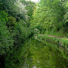
English: Marsh Lane "Narrows", near Wolverhampton The Staffordshire and Worcestershire Canal. The narrows are cut into the sandstone rock, and for half a mile or so narrowboats cannot pass each other. There are two wider spots in the narrows where one (maybe two) boat(s) can pass another coming the other way. This picture shows the southern one. The latest Nicholson Guide mentions that locally the stretch is called "Pendeford Rockin'", after a local farm.
The white blossom on the trees is Hawthorn, or Mayflower. |
| Date | |
| Source | From geograph.org.uk |
| Author | Roger Kidd |
| Attribution (required by the license) | Roger Kidd / Marsh Lane "Narrows", near Wolverhampton / |
| Camera location | | View this and other nearby images on: OpenStreetMap |
|---|
_heading:202.00&language=en)
| Object location | | View this and other nearby images on: OpenStreetMap |
|---|
_heading:202.00&language=en)
Licensing edit

|
This image was taken from the Geograph project collection. See this photograph's page on the Geograph website for the photographer's contact details. The copyright on this image is owned by Roger Kidd and is licensed for reuse under the Creative Commons Attribution-ShareAlike 2.0 license.
|
This file is licensed under the Creative Commons Attribution-Share Alike 2.0 Generic license.
Attribution: Roger Kidd
- You are free:
- to share – to copy, distribute and transmit the work
- to remix – to adapt the work
- Under the following conditions:
- attribution – You must give appropriate credit, provide a link to the license, and indicate if changes were made. You may do so in any reasonable manner, but not in any way that suggests the licensor endorses you or your use.
- share alike – If you remix, transform, or build upon the material, you must distribute your contributions under the same or compatible license as the original.
File history
Click on a date/time to view the file as it appeared at that time.
| Date/Time | Thumbnail | Dimensions | User | Comment | |
|---|---|---|---|---|---|
| current | 21:48, 27 February 2011 | | 640 × 640 (153 KB) | GeographBot (talk | contribs) | == {{int:filedesc}} == {{Information |description={{en|1=Marsh Lane "Narrows", near Wolverhampton The Staffordshire and Worcestershire Canal. The narrows are cut into the sandstone rock, and for half a mile or so narrowboats cannot pass each other. There |
You cannot overwrite this file.
File usage on Commons
There are no pages that use this file.