File:Marstonia comalensis map.png

Size of this preview: 652 × 599 pixels. Other resolutions: 261 × 240 pixels | 522 × 480 pixels | 836 × 768 pixels | 1,114 × 1,024 pixels | 1,509 × 1,387 pixels.
Original file (1,509 × 1,387 pixels, file size: 477 KB, MIME type: image/png)
Captions
Captions
Add a one-line explanation of what this file represents
| Description |
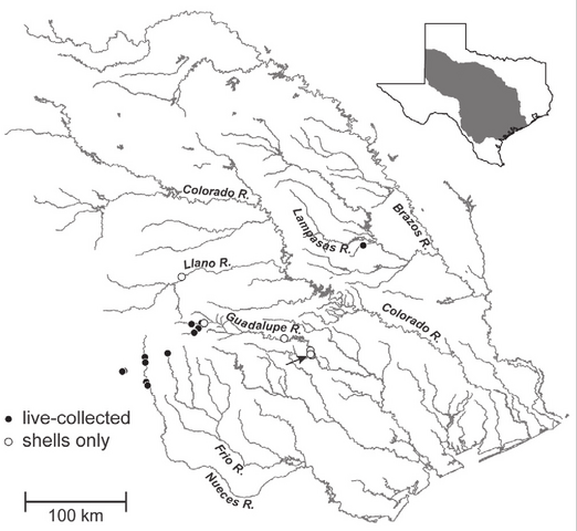
English: Map showing the distribution of Marstonia comalensis in the Brazos, Colorado, Guadalupe and Nueces River basins, south-central Texas. The arrow indicates the type locality (Comal Creek). |
| Date | |
| Source | Hershler R. & Liu H.-P. (2011). "Redescription of Marstonia comalensis (Pilsbry & Ferriss, 1906), a poorly known and possibly threatened freshwater gastropod from the Edwards Plateau region (Texas)". ZooKeys 77: 1-16. doi:10.3897/zookeys.77.935. Figure 4. Extracted in 300 dpi. |
| Author | Robert Hershler & Hsiu-Ping Liu |
This file is licensed under the Creative Commons Attribution 3.0 Unported license.
|
File history
Click on a date/time to view the file as it appeared at that time.
| Date/Time | Thumbnail | Dimensions | User | Comment | |
|---|---|---|---|---|---|
| current | 20:10, 29 March 2011 | | 1,509 × 1,387 (477 KB) | Snek01 (talk | contribs) | {{Information |Description={{en|Distribution map of ''Marstonia comalensis''.}} |Source=Hershler R. & Liu H.-P. (2011). "Redescription of ''Marstonia comalensis'' (Pilsbry & Ferriss, 1906), a poorly known and possibly threatened freshwater gastropod from |
You cannot overwrite this file.
File usage on Commons
There are no pages that use this file.
File usage on other wikis
The following other wikis use this file:
- Usage on en.wikipedia.org