File:Mataheh.jpg
Mataheh.jpg (376 × 357 pixels, file size: 289 KB, MIME type: image/jpeg)
Captions
Captions
Summary edit
| Description |
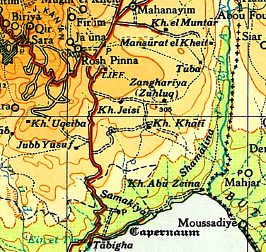
English: Operation Mataheh: area cleared of bedouin encampments 1948 |
|||
| Date | ||||
| Source | [1] | |||
| Author | Survey of Palestine map (1944) prepared for the 1946 Anglo-American Committee of Enquiry by the British mandatory authorities. Grid = 10km. | |||
| Permission (Reusing this file) |
|

![[1]](http://cs.anu.edu.au/~bdm/yabber/survey1944/SofP1.jpg)
File history
Click on a date/time to view the file as it appeared at that time.
| Date/Time | Thumbnail | Dimensions | User | Comment | |
|---|---|---|---|---|---|
| current | 10:01, 16 July 2013 | | 376 × 357 (289 KB) | Padres Hana (talk | contribs) | User created page with UploadWizard |
You cannot overwrite this file.
File usage on Commons
There are no pages that use this file.
File usage on other wikis
The following other wikis use this file:
- Usage on ar.wikipedia.org
- Usage on en.wikipedia.org