File:Maupiti topographic map-fr.svg

Size of this PNG preview of this SVG file: 460 × 599 pixels. Other resolutions: 184 × 240 pixels | 368 × 480 pixels | 589 × 768 pixels | 786 × 1,024 pixels | 1,572 × 2,048 pixels | 469 × 611 pixels.
Original file (SVG file, nominally 469 × 611 pixels, file size: 1.68 MB)
Captions
Captions
Add a one-line explanation of what this file represents
Summary edit
| Description | |
| Date | |
| Source |
Œuvre personnelle.
Données :
Logiciels utilisés :
Autres informations :
|
| Author | Sardon |
| Other versions | Macedonian version |
Licensing edit
| I, the copyright holder of this work, release this work into the public domain. This applies worldwide. In some countries this may not be legally possible; if so: I grant anyone the right to use this work for any purpose, without any conditions, unless such conditions are required by law. |
File history
Click on a date/time to view the file as it appeared at that time.
| Date/Time | Thumbnail | Dimensions | User | Comment | |
|---|---|---|---|---|---|
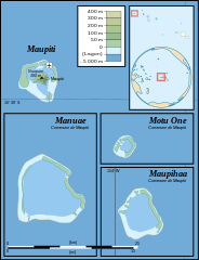
| current | 17:23, 23 November 2008 | | 469 × 611 (1.68 MB) | Sardon (talk | contribs) | {{Information |Description={{en|1=Topographic map in French of the islands of Maupiti, Motu One, Manuae and Maupihaa, Society Islands, French Polynesia.}} |
You cannot overwrite this file.
File usage on Commons
The following 2 pages use this file:
_topographic_map-fr.svg)
_topographic_map-mk.svg)
File usage on other wikis
The following other wikis use this file:
- Usage on de.wikipedia.org
- Usage on eo.wikipedia.org
- Usage on es.wikipedia.org
- Usage on fr.wikipedia.org
- Usage on it.wikipedia.org
- Usage on lt.wikipedia.org
- Usage on no.wikipedia.org
- Usage on oc.wikipedia.org
- Usage on pl.wikipedia.org
- Usage on pt.wikipedia.org