File:Meiko Triton Route.png

Size of this preview: 800 × 531 pixels. Other resolutions: 320 × 213 pixels | 640 × 425 pixels | 1,024 × 680 pixels | 1,280 × 850 pixels | 2,896 × 1,924 pixels.
Original file (2,896 × 1,924 pixels, file size: 6.84 MB, MIME type: image/png)
Captions
Captions
Add a one-line explanation of what this file represents
Summary edit
| Description |
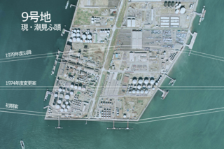
日本語: 名港トリトンの9号地(現・潮見ふ頭)通過ルートの変遷。典拠:『第23回技術報告会資料 道路編』建設省中部地方建設局、昭和49年8月、26頁 |
| Date | |
| Source | 国土画像情報(カラー空中写真)(CCB7528-C42-49を加工) |
| Author | 国土地理院 |
Licensing edit

|
The copyright holder of this file, the Ministry of Land, Infrastructure, Transport and Tourism of Japan, allows anyone to use it for any purpose, provided that the copyright holder is properly attributed. Redistribution, derivative work, commercial use, and all other use is permitted. |
Attribution:
Copyright © National Land Image Information (Color Aerial Photographs), Ministry of Land, Infrastructure, Transport and Tourism
|
 |
This image is copyrighted by the Ministry of Land, Infrastructure, Transport and Tourism of Japan. For terms of use, see the stipulation to use of National Land Information (in Japanese) and message from MLIT (in Japanese and English). When you display this image on an article, include the following phrase in the description: "Made based on National Land Image Information (Color Aerial Photographs), Ministry of Land, Infrastructure, Transport and Tourism".
|
File history
Click on a date/time to view the file as it appeared at that time.
| Date/Time | Thumbnail | Dimensions | User | Comment | |
|---|---|---|---|---|---|
| current | 08:43, 6 January 2018 | | 2,896 × 1,924 (6.84 MB) | Oka21000 (talk | contribs) | {{Information |Description ={{ja|1=名港トリトンの9号地(現・潮見ふ頭)通過ルートの変遷。典拠:『第23回技術報告会資料 道路編』建設省中部地方建設局、昭和49年8月、26頁}} |Source =国... |
You cannot overwrite this file.
File usage on Commons
The following page uses this file:
File usage on other wikis
The following other wikis use this file:
- Usage on ja.wikipedia.org