File:Melbourne passenger railways map.svg

Size of this PNG preview of this SVG file: 512 × 462 pixels. Other resolutions: 266 × 240 pixels | 532 × 480 pixels | 851 × 768 pixels | 1,135 × 1,024 pixels | 2,270 × 2,048 pixels.
Original file (SVG file, nominally 512 × 462 pixels, file size: 309 KB)
Captions
Captions
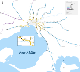
Map of Melbourne's metropolitan passenger rail network
Summary edit
| Description |
English: Map of Melbourne's metropolitan passenger rail network. |
| Date | |
| Source | Own work |
| Author | Philip Mallis |
W3C-validity not checked.
Licensing edit
I, the copyright holder of this work, hereby publish it under the following license:
This file is licensed under the Creative Commons Attribution-Share Alike 4.0 International license.
- You are free:
- to share – to copy, distribute and transmit the work
- to remix – to adapt the work
- Under the following conditions:
- attribution – You must give appropriate credit, provide a link to the license, and indicate if changes were made. You may do so in any reasonable manner, but not in any way that suggests the licensor endorses you or your use.
- share alike – If you remix, transform, or build upon the material, you must distribute your contributions under the same or compatible license as the original.
File history
Click on a date/time to view the file as it appeared at that time.
| Date/Time | Thumbnail | Dimensions | User | Comment | |
|---|---|---|---|---|---|
| current | 23:30, 5 July 2021 | | 512 × 462 (309 KB) | Takerlamar (talk | contribs) | Added new Cobblebank Station |
| 21:32, 7 February 2019 |  | 4,975 × 4,493 (156 KB) | Takerlamar (talk | contribs) | Fixed coding issues. Category:Public transport maps of Australia Category:Rail transport maps of Australia | |
| 23:03, 13 November 2017 |  | 512 × 462 (137 KB) | Takerlamar (talk | contribs) | User created page with UploadWizard |
You cannot overwrite this file.
File usage on Commons
The following 11 pages use this file:
- User:Chumwa/OgreBot/Potential transport maps/2017 November 11-20
- User:Chumwa/OgreBot/Potential transport maps/2019 February 1-9
- User:Chumwa/OgreBot/Public transport information/2017 November 11-20
- User:Chumwa/OgreBot/Public transport information/2019 February 1-9
- User:Chumwa/OgreBot/Public transport information/2021 July 1-10
- User:Chumwa/OgreBot/Transport Maps/2017 November 11-20
- User:Chumwa/OgreBot/Transport Maps/2019 February 1-9
- User:Chumwa/OgreBot/Transport Maps/2021 July 1-10
- User:Chumwa/OgreBot/Travel and communication maps/2017 November 11-20
- User:Chumwa/OgreBot/Travel and communication maps/2019 February 1-9
- File:Melbourne passenger railways map.png
File usage on other wikis
The following other wikis use this file:
- Usage on de.wikipedia.org
- Usage on nl.wikipedia.org