File:Metro montreal geographical map 1984.png

Size of this preview: 582 × 599 pixels. Other resolutions: 233 × 240 pixels | 466 × 480 pixels | 746 × 768 pixels | 1,157 × 1,191 pixels.
Original file (1,157 × 1,191 pixels, file size: 265 KB, MIME type: image/png)
Captions
Captions
Add a one-line explanation of what this file represents
Summary
edit
| Description |
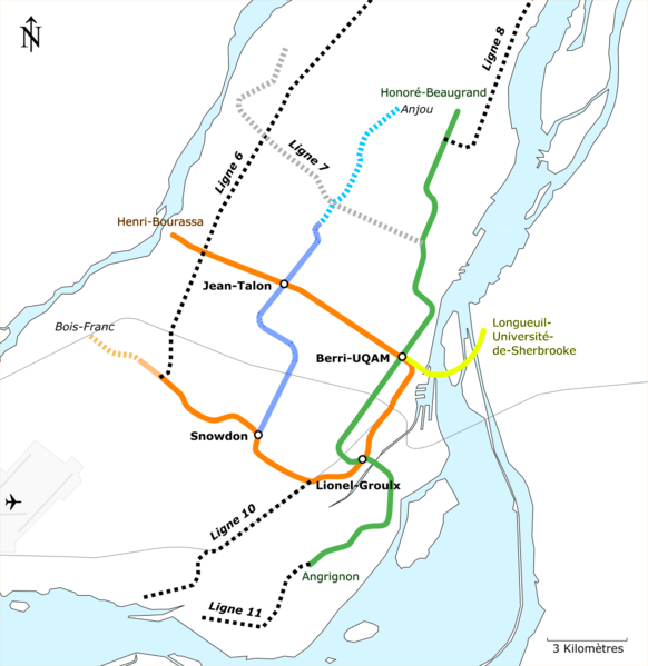
Français : Plan géographiquement exact des lignes de métro et de trains de banlieue existantes, en travaux et projetées par le Ministère des Transports du Québec en 1981 (ligne 6 de surface) et la Communauté Urbaine de Montréal en 1983/1984 (ligne 7 souterraine dans sa version Pie-IX/Lionel-Groulx et lignes de surface 8,10 et 11). |
| Date | |
| Source | Ministère des Transports du Québec, Société de Transport de la Communauté urbaine de Montréal |
| Author | Calvin411 |
Licensing
edit
I, the copyright holder of this work, hereby publish it under the following license:
This file is licensed under the Creative Commons Attribution-Share Alike 4.0 International license.
- You are free:
- to share – to copy, distribute and transmit the work
- to remix – to adapt the work
- Under the following conditions:
- attribution – You must give appropriate credit, provide a link to the license, and indicate if changes were made. You may do so in any reasonable manner, but not in any way that suggests the licensor endorses you or your use.
- share alike – If you remix, transform, or build upon the material, you must distribute your contributions under the same or compatible license as the original.
File history
Click on a date/time to view the file as it appeared at that time.
| Date/Time | Thumbnail | Dimensions | User | Comment | |
|---|---|---|---|---|---|
| current | 20:25, 21 February 2017 | | 1,157 × 1,191 (265 KB) | Calvin411 (talk | contribs) | Line 7 path updated |
| 22:27, 18 September 2016 |  | 1,157 × 1,191 (261 KB) | Calvin411 (talk | contribs) | Cross-wiki upload from fr.wikipedia.org |
You cannot overwrite this file.
File usage on Commons
The following 8 pages use this file:
- User:Chumwa/OgreBot/Potential transport maps/2016 September 11-20
- User:Chumwa/OgreBot/Potential transport maps/2017 February 19-28
- User:Chumwa/OgreBot/Public transport information/2016 September 11-20
- User:Chumwa/OgreBot/Public transport information/2017 February 19-28
- User:Chumwa/OgreBot/Transport Maps/2016 September 11-20
- User:Chumwa/OgreBot/Transport Maps/2017 February 19-28
- User:Chumwa/OgreBot/Travel and communication maps/2016 September 11-20
- User:Chumwa/OgreBot/Travel and communication maps/2017 February 19-28
File usage on other wikis
The following other wikis use this file:
- Usage on en.wikipedia.org
- Usage on fr.wikipedia.org
- Usage on ko.wikipedia.org