File:Metrosideros umbellata distribution.png
No higher resolution available.
Metrosideros_umbellata_distribution.png (800 × 590 pixels, file size: 8 KB, MIME type: image/png)
Captions
Captions
Add a one-line explanation of what this file represents
Summary edit
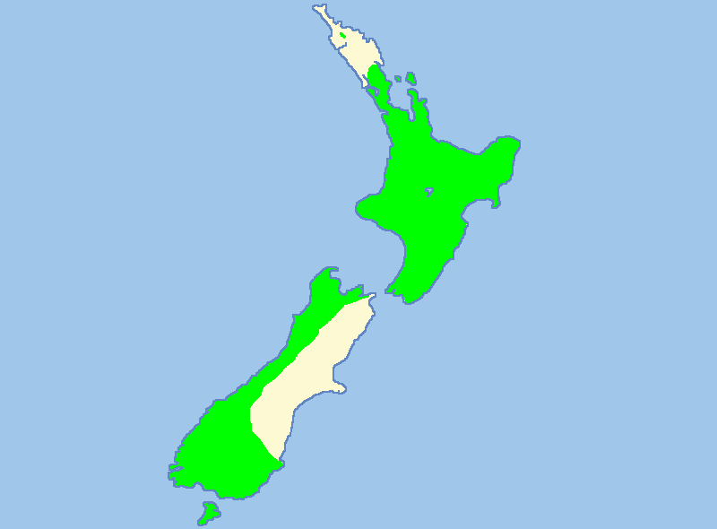
| Description | Distribution map of Metrosideros umbellata (Southern Rātā) in New Zealand. The North Island distribution is much more localised and scattered than this map suggests - it is quite a rare tree there, occuring on occasional mountain tops. The map also omits the southern end of the range in the subantarctic islands to the south of the South Island. |
| Date | |
| Source | Own work. Based on Image:NZ_Locator_Blank.png and [1]. |
| Author | User:Carstor |
| Permission (Reusing this file) |
GFDL-own |

|
This biogeographical map image could be re-created using vector graphics as an SVG file. This has several advantages; see Commons:Media for cleanup for more information. If an SVG form of this image is available, please upload it and afterwards replace this template with
{{vector version available|new image name}}.
It is recommended to name the SVG file “Metrosideros umbellata distribution.svg”—then the template Vector version available (or Vva) does not need the new image name parameter. |
Licensing edit
I, the copyright holder of this work, hereby publish it under the following licenses:

|
Permission is granted to copy, distribute and/or modify this document under the terms of the GNU Free Documentation License, Version 1.2 or any later version published by the Free Software Foundation; with no Invariant Sections, no Front-Cover Texts, and no Back-Cover Texts. A copy of the license is included in the section entitled GNU Free Documentation License. |
| This file is licensed under the Creative Commons Attribution-Share Alike 3.0 Unported license. | ||
| ||
| This licensing tag was added to this file as part of the GFDL licensing update. |
You may select the license of your choice.
File history
Click on a date/time to view the file as it appeared at that time.
| Date/Time | Thumbnail | Dimensions | User | Comment | |
|---|---|---|---|---|---|
| current | 09:20, 10 February 2007 | | 800 × 590 (8 KB) | Carstor (talk | contribs) | {{Information |Description = Distribution map of ''Metrosideros umbellata'' (Southern Rata) in New Zealand. Based on Image:NZ_Locator_Blank.png and [https://www.projectcrimson.org.nz/fact-sheet/]. |Source = Own work |Date = 09. Feb 2007 |Author = |
You cannot overwrite this file.
File usage on Commons
The following 2 pages use this file:
File usage on other wikis
The following other wikis use this file:
- Usage on ar.wikipedia.org
- Usage on ceb.wikipedia.org
- Usage on de.wikipedia.org
- Usage on en.wikipedia.org
- Usage on es.wikipedia.org
- Usage on fr.wikipedia.org
- Usage on ja.wikipedia.org
- Usage on mi.wikipedia.org
- Usage on nl.wikipedia.org
- Usage on nn.wikipedia.org
- Usage on sv.wikipedia.org
- Usage on vi.wikipedia.org
- Usage on www.wikidata.org
- Usage on zh.wikipedia.org