File:Mexico 1835-1846 administrative map-de.svg

Size of this PNG preview of this SVG file: 654 × 600 pixels. Other resolutions: 262 × 240 pixels | 523 × 480 pixels | 838 × 768 pixels | 1,117 × 1,024 pixels | 2,233 × 2,048 pixels | 1,241 × 1,138 pixels.
Original file (SVG file, nominally 1,241 × 1,138 pixels, file size: 162 KB)
Captions
Captions
Add a one-line explanation of what this file represents
Summary edit
| Description |
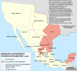
[] Deutsch: Administrative Karte Mexikos in den Jahren 1835-1846. English: Administrative map of Mexico during the two central republics (1835-1846). Español: Mapa de la organización territorial de México durante las Repúblicas Centralistas (1835-1846). Français : Carte du Mexique durant les deux républiques centrales (1935-1846). |
| Date | |
| Source | |
| Author | Sémhur, Furfur |
| Other versions |
[]
|
| SVG development | This diagram was created with Inkscape. This diagram uses embedded text that can be easily translated using a text editor. |


.svg)


Licensing edit
I, the copyright holder of this work, hereby publish it under the following licenses:
This file is licensed under the Creative Commons Attribution-Share Alike 3.0 Unported, 2.5 Generic, 2.0 Generic and 1.0 Generic license.
- You are free:
- to share – to copy, distribute and transmit the work
- to remix – to adapt the work
- Under the following conditions:
- attribution – You must give appropriate credit, provide a link to the license, and indicate if changes were made. You may do so in any reasonable manner, but not in any way that suggests the licensor endorses you or your use.
- share alike – If you remix, transform, or build upon the material, you must distribute your contributions under the same or compatible license as the original.

|
Permission is granted to copy, distribute and/or modify this document under the terms of the GNU Free Documentation License, Version 1.2 or any later version published by the Free Software Foundation; with no Invariant Sections, no Front-Cover Texts, and no Back-Cover Texts. A copy of the license is included in the section entitled GNU Free Documentation License. |
You may select the license of your choice.
Uploaded with derivativeFX
File history
Click on a date/time to view the file as it appeared at that time.
| Date/Time | Thumbnail | Dimensions | User | Comment | |
|---|---|---|---|---|---|
| current | 18:59, 28 December 2019 | | 1,241 × 1,138 (162 KB) | Furfur (talk | contribs) | some graphical improvements |
| 23:55, 3 March 2010 |  | 1,241 × 1,138 (239 KB) | Furfur (talk | contribs) | {{Information |Description={{de|1=Administrative Karte Mexikos in den Jahren 1835-1846.}}{{fr|1=Carte du Mexique durant les deux républiques centrales (1935-1846).}}{{en|1=Administrative map of Mexico during the two central republics (1835-1846).}} {{es| |
You cannot overwrite this file.
File usage on Commons
The following 11 pages use this file:
- File:División política de México (1836-1846).svg
- File:File-Mexico 1835-1846 administrative map-en-2.svg
- File:File-Mexico 1835-1846 administrative map-ru-2.svg
- File:Mexico 1835-1846 administrative map-de.svg
- File:Mexico 1835-1846 administrative map-en-2.svg
- File:Mexico 1835-1846 administrative map-en.svg
- File:Mexico 1835-1846 administrative map-es.svg
- File:Mexico 1835-1846 administrative map-fr.svg
- File:Mexico 1835-1846 administrative map-it.svg
- File:México División Política-República Central.png
- Template:Other versions/Mexico 1835-1846 administrative map
File usage on other wikis
The following other wikis use this file:
- Usage on de.wikipedia.org