File:Middle East Map 1540.jpg
No higher resolution available.
Middle_East_Map_1540.jpg (652 × 521 pixels, file size: 118 KB, MIME type: image/jpeg)
Captions
Captions
Add a one-line explanation of what this file represents
Summary edit
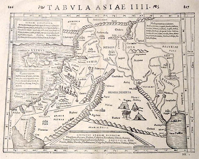
| Description |
TABVLA ASIAE IV - Middle East (Ptolemy) |
| Date | |
| Source | Self-scanned |
| Author | Münster |
| Permission (Reusing this file) |
Public Domain |
| Other versions |
|
_p_111.jpg)


Licensing edit
|
This work is in the public domain in its country of origin and other countries and areas where the copyright term is the author's life plus 100 years or fewer. | |
| This file has been identified as being free of known restrictions under copyright law, including all related and neighboring rights. | |
File history
Click on a date/time to view the file as it appeared at that time.
| Date/Time | Thumbnail | Dimensions | User | Comment | |
|---|---|---|---|---|---|
| current | 03:33, 30 November 2006 | | 652 × 521 (118 KB) | Tarawneh (talk | contribs) | {{Information |Description= TABVLA ASIAE IV - Middle East (Ptolemy) <br> Issued in Basle in the year 1540.<br> Original size 25.0 x 34.4 (hxw cms)<br> Technique used: Woodcut |Source= Scanned |Date= 1540 |Author= Münster |Permission= Public Domain |oth |
You cannot overwrite this file.
File usage on Commons
The following 4 pages use this file:
- File:Cosmographia (Sebastian Münster) p 111.jpg
- File:PG UFL2.jpg
- File:Sebastian Münster, Ptolemy. TABVLA ASIAE IIII on verso QVARTA ASIAE tabula continet Cyprum, Syriam, Palestinam. Basel; Henricus Petri. 30 x 39 cm. 1545.jpg
- File:Sebastian Münster. Syria, Cypern, Palestina, Mesopotamia, Babylonia, zwey Arabia, mit Bergen, Wasseren und Stetten. Basel; Henricus Petri. 30.3 x 35.7 cm. 1588.jpg
File usage on other wikis
The following other wikis use this file:
- Usage on de.wikipedia.org