File:Mill-Pine Neighborhood HD boundary map.png

Size of this preview: 666 × 600 pixels. Other resolutions: 267 × 240 pixels | 533 × 480 pixels | 784 × 706 pixels.
Original file (784 × 706 pixels, file size: 236 KB, MIME type: image/png)
Captions
Captions
Add a one-line explanation of what this file represents
Summary edit
| Description |
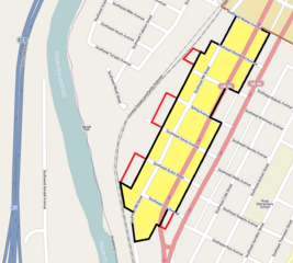
English: Map showing the boundaries of the Mill-Pine Neighborhood Historic District in Roseburg, Oregon, United States. The historic district is listed on the US National Register of Historic Places. Boundary data is derived from the historic district's National Register nomination form, as well as the National Register file for the district's boundary decrease dated September 26, 2011.
|
| Date | |
| Source | Exported screenshot from OpenStreetMap, with district boundary drawn by uploader. |
| Author |
Base map: OpenStreetMap contributors District boundaries/shading: Ian Poellet |
| Permission (Reusing this file) |
Base map: © OpenStreetMap contributors. Current license information available at http://www.openstreetmap.org/copyright. |
Licensing edit
This file is licensed under the Creative Commons Attribution-Share Alike 2.0 Generic license.
- You are free:
- to share – to copy, distribute and transmit the work
- to remix – to adapt the work
- Under the following conditions:
- attribution – You must give appropriate credit, provide a link to the license, and indicate if changes were made. You may do so in any reasonable manner, but not in any way that suggests the licensor endorses you or your use.
- share alike – If you remix, transform, or build upon the material, you must distribute your contributions under the same or compatible license as the original.
File history
Click on a date/time to view the file as it appeared at that time.
| Date/Time | Thumbnail | Dimensions | User | Comment | |
|---|---|---|---|---|---|
| current | 20:40, 13 May 2013 | | 784 × 706 (236 KB) | Werewombat (talk | contribs) | Shade district area |
| 04:40, 2 May 2013 |  | 784 × 706 (232 KB) | Werewombat (talk | contribs) | User created page with UploadWizard |
You cannot overwrite this file.
File usage on Commons
The following 2 pages use this file:
File usage on other wikis
The following other wikis use this file:
- Usage on de.wikipedia.org
- Usage on en.wikipedia.org
- Usage on www.wikidata.org