File:Millerd1728dhotwells.jpg

Size of this preview: 306 × 599 pixels. Other resolutions: 122 × 240 pixels | 245 × 480 pixels | 392 × 768 pixels | 523 × 1,024 pixels | 1,434 × 2,806 pixels.
Original file (1,434 × 2,806 pixels, file size: 2.79 MB, MIME type: image/jpeg)
Captions
Captions
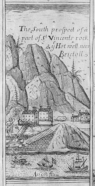
Original caption: 'The South prospect of a part of St Vincents rock in the Hot well neer Bristol' (1673)
Summary edit
| Description |
English: Depiction of the Hotwell in James Millerd's 1728 map of Bristol. Image is unchanged from the 1673 version of the map. Images shows the Hotwells spa with a man in the foreground 'taking the waters'. |
| Date | |
| Source | Detail from the 1728 updated edition of James Millerd's map An Exact Delineation of the Famous Citty of Bristoll and Suburbs, first published in 1673. Digitisation undertaken by the Bristol Record Society of an engraving owned by the Society of Merchant Venturers, Bristol. |
| Author | James Millerd and unknown later editors. |
| Permission (Reusing this file) |
The Society of Merchant Venturers and the Bristol Record Society make the images freely available on a creative commons license (2020). If reproducing the images in a publication, in whole or part, please acknowledge the Society of Merchant Venturers. |
| Camera location | | View this and other nearby images on: OpenStreetMap |
|---|
Licensing edit
|
This work is in the public domain in its country of origin and other countries and areas where the copyright term is the author's life plus 70 years or fewer. This work is in the public domain in the United States because it was published (or registered with the U.S. Copyright Office) before January 1, 1929. | |
| This file has been identified as being free of known restrictions under copyright law, including all related and neighboring rights. | |
File history
Click on a date/time to view the file as it appeared at that time.
| Date/Time | Thumbnail | Dimensions | User | Comment | |
|---|---|---|---|---|---|
| current | 18:06, 16 June 2023 | | 1,434 × 2,806 (2.79 MB) | Evan T Jones (talk | contribs) | Uploaded a work by James Millerd from Detail from James Millerd's 1728 map of Bristol with UploadWizard |
You cannot overwrite this file.
File usage on Commons
There are no pages that use this file.
File usage on other wikis
The following other wikis use this file:
- Usage on en.wikipedia.org