File:Millstätter Berg Obermillstatt Lammersdorf 2013a.jpg

Size of this preview: 798 × 600 pixels. Other resolutions: 320 × 240 pixels | 639 × 480 pixels | 1,022 × 768 pixels | 1,280 × 962 pixels | 2,560 × 1,924 pixels | 4,332 × 3,255 pixels.
Original file (4,332 × 3,255 pixels, file size: 4.62 MB, MIME type: image/jpeg)
Captions
Captions
Add a one-line explanation of what this file represents
Summary edit
| Description |
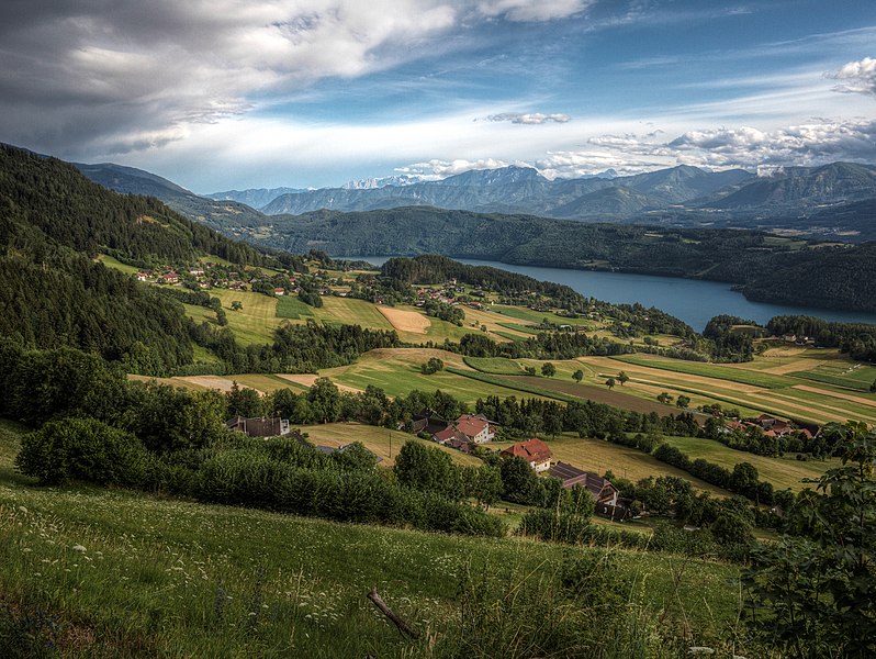
Deutsch: Im Vordergrund einige Häuser von Obermillstatt. Dahinter die Westansicht von Grantsch und Lammersdorf am Millstätter Berg (Hochplateau) über dem Millstättersee in Kärnten / Österreich / Europäische Union. Im Hintergrund der Millstätter See, dahinter der Millstätter See Rücken. Dahinter der etwas höhere Berg ist der Dobratsch in den Gailtaler Alpen und aufgrund der guten Fernsicht sind sogar die Julischen Alpen rechts vom Dobratsch, links davon die Karawanken in mehr als 80 km Entfernung sichtbar. Sommer, Abendstimmung, nach einem Gewitter. Die Wolken rechts stauen sich vor der Millstätter Alpe. English: In the foreground, a few houses from Obermillstatt near Lake Millstatt (Millstätter See), district Spittal an der Drau in Carinthia / Austria / EU. Behind the western view of Grantsch and Lammersdorf. In the background of the Lake Millstatt. Behind the slightly higher peak is the en:Dobratsch Dobratsch in the Gail Valley Alps and because of the good distance vision, even the Julian Alps to the right of Dobratsch left of the Karawanken are visible in more than 80 km away. Summer Evening, after a thunderstorm. The clouds pile up right in front of the Alpe Millstaetter. |
|
| Date | ||
| Source | Own work | |
| Author | Joadl, special thanks to Alois Auer vlg Messner | |
| Permission (Reusing this file) |
|
| Object location | | View this and other nearby images on: OpenStreetMap |
|---|
| This is a retouched picture, which means that it has been digitally altered from its original version. Modifications: HDRI/Tone mapping with Photomatix Pro 4.2 of 3 RAW.
|
Licensing edit
I, the copyright holder of this work, hereby publish it under the following licenses:

|
Permission is granted to copy, distribute and/or modify this document under the terms of the GNU Free Documentation License, Version 1.2 or any later version published by the Free Software Foundation; with no Invariant Sections, no Front-Cover Texts, and no Back-Cover Texts. A copy of the license is included in the section entitled GNU Free Documentation License. |
This file is licensed under the Creative Commons Attribution-Share Alike 3.0 Austria license.
- You are free:
- to share – to copy, distribute and transmit the work
- to remix – to adapt the work
- Under the following conditions:
- attribution – You must give appropriate credit, provide a link to the license, and indicate if changes were made. You may do so in any reasonable manner, but not in any way that suggests the licensor endorses you or your use.
- share alike – If you remix, transform, or build upon the material, you must distribute your contributions under the same or compatible license as the original.

You may select the license of your choice.
File history
Click on a date/time to view the file as it appeared at that time.
| Date/Time | Thumbnail | Dimensions | User | Comment | |
|---|---|---|---|---|---|
| current | 18:49, 6 August 2013 | | 4,332 × 3,255 (4.62 MB) | Joadl (talk | contribs) | == {{int:filedesc}} == {{Information |Description= {{Multilingual description |de=Beschreibung folgt |en=comming soon}} |Source={{own}} |Date=2012-07-30 |Author=Joadl |Permission={{User:Joadl/Ref}} |other_versions= }} {{Location|46|41|40... |
You cannot overwrite this file.
File usage on Commons
The following 4 pages use this file:
File usage on other wikis
The following other wikis use this file:
- Usage on ar.wikipedia.org
- Usage on de.wikipedia.org
- Usage on en.wikipedia.org