File:Mimas atlas 2008 PIA11117.jpg

Original file (3,936 × 3,936 pixels, file size: 1.42 MB, MIME type: image/jpeg)
Captions
Captions
Summary edit
| Description |
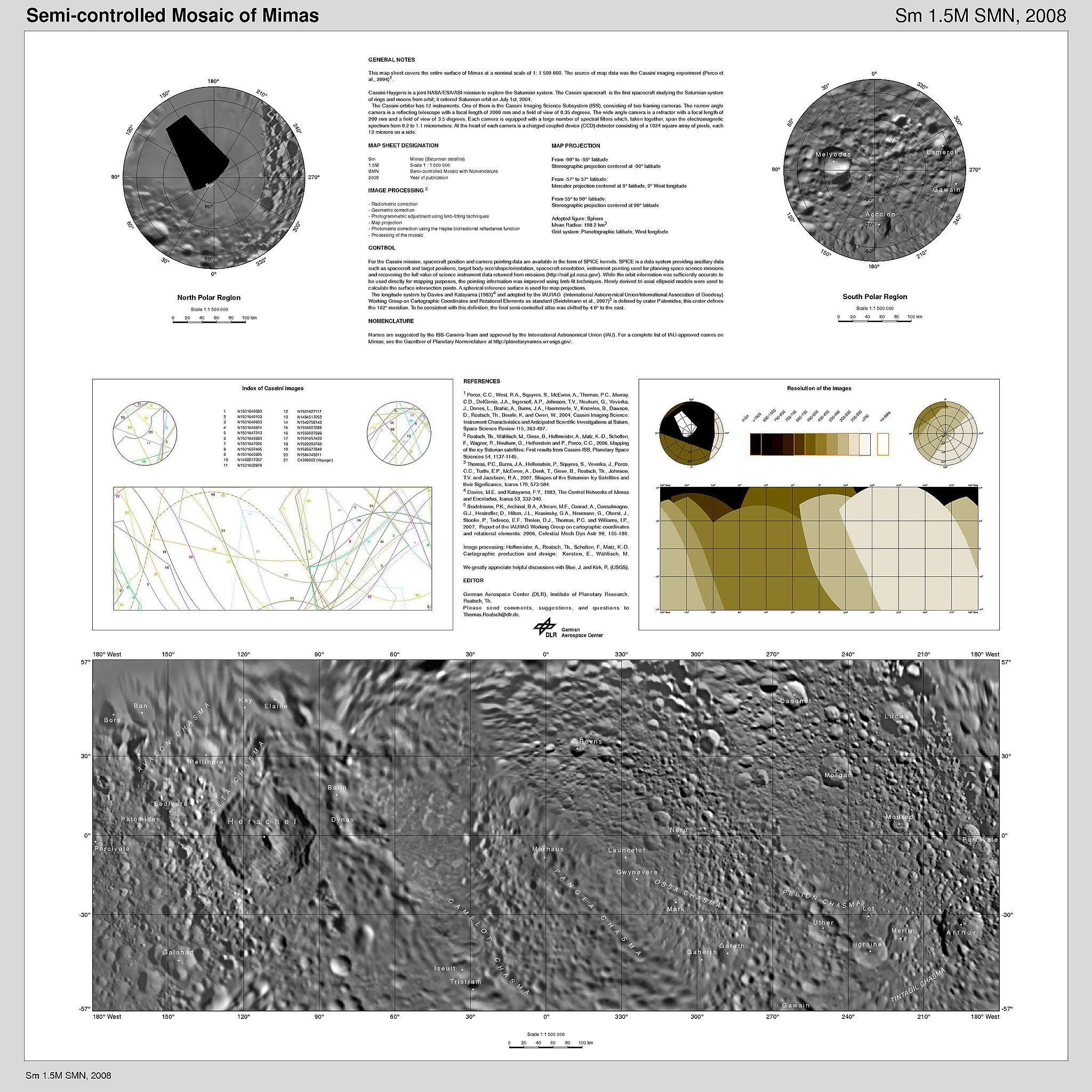
English: Presented here is a cartographic map sheet which forms a high-resolution Mimas atlas, a project of the Cassini Imaging Team.
Mimas, as imaged by the Voyager spacecraft in the early 1980s, has a very large, distinguishing crater that makes it look like the "Death Star." As shown in this map, that crater is named Herschel. The map sheets form a three-quadrangle series covering the entire surface of Mimas at a nominal scale of 1:1,500,000. The map data was acquired by the Cassini imaging experiment. The mean radius of Mimas used for projection of the maps is 198.2 kilometers (123.2 miles). Names for features have been approved by the International Astronomical Union (IAU). The Cassini-Huygens mission is a cooperative project of NASA, the European Space Agency and the Italian Space Agency. The Jet Propulsion Laboratory, a division of the California Institute of Technology in Pasadena, manages the mission for NASA's Science Mission Directorate, Washington, D.C. The Cassini orbiter and its two onboard cameras were designed, developed and assembled at JPL. The imaging operations center is based at the Space Science Institute in Boulder, Colo. For more information about the Cassini-Huygens mission visit http://saturn.jpl.nasa.gov/. The Cassini imaging team homepage is at http://ciclops.org. |
| Date | |
| Source | http://photojournal.jpl.nasa.gov/catalog/PIA11117 |
| Author | NASA/JPL/Space Science Institute |
Licensing edit
| This file is in the public domain in the United States because it was solely created by NASA. NASA copyright policy states that "NASA material is not protected by copyright unless noted". (See Template:PD-USGov, NASA copyright policy page or JPL Image Use Policy.) | ||
 |
Warnings:
|
File history
Click on a date/time to view the file as it appeared at that time.
| Date/Time | Thumbnail | Dimensions | User | Comment | |
|---|---|---|---|---|---|
| current | 16:40, 18 October 2008 | | 3,936 × 3,936 (1.42 MB) | Bryan Derksen (talk | contribs) | {{Information |Description={{en|1=Presented here is a cartographic map sheet which forms a high-resolution Mimas atlas, a project of the Cassini Imaging Team. Mimas, as imaged by the Voyager spacecraft in the early 1980s, has a very large, distinguishing |
You cannot overwrite this file.
File usage on Commons
There are no pages that use this file.