File:Minden, 2. Gegenangriff.png

Size of this preview: 800 × 596 pixels. Other resolutions: 320 × 238 pixels | 640 × 477 pixels | 1,024 × 763 pixels | 1,170 × 872 pixels.
Original file (1,170 × 872 pixels, file size: 289 KB, MIME type: image/png)
Captions
Captions
Add a one-line explanation of what this file represents
Summary edit
| Description |
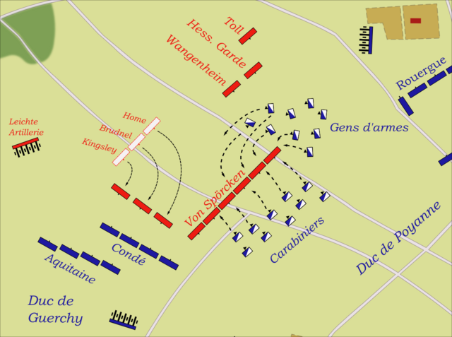
Deutsch: (Deutsche) Karte vom zweiten Versuch der französischen Truppen die Division von Spörcken während der Schlacht bei Minden 1759 zu zerschlagen.
English: (German) Map showing the second French attempt to crash the Division von Spörken during the Battle of Minden 1759. |
| Date | |
| Source | Own work |
| Author | Memnon335bc |
| Object location | | View this and other nearby images on: OpenStreetMap |
|---|
Licensing edit
I, the copyright holder of this work, hereby publish it under the following license:
This file is licensed under the Creative Commons Attribution 3.0 Unported license.
- You are free:
- to share – to copy, distribute and transmit the work
- to remix – to adapt the work
- Under the following conditions:
- attribution – You must give appropriate credit, provide a link to the license, and indicate if changes were made. You may do so in any reasonable manner, but not in any way that suggests the licensor endorses you or your use.
File history
Click on a date/time to view the file as it appeared at that time.
| Date/Time | Thumbnail | Dimensions | User | Comment | |
|---|---|---|---|---|---|
| current | 10:13, 13 July 2009 | | 1,170 × 872 (289 KB) | Memnon335bc (talk | contribs) | correct small things |
| 01:54, 20 June 2009 |  | 1,170 × 872 (287 KB) | Memnon335bc (talk | contribs) | {{Information |Description={{de|1=(Deutsche) Karte vom zweiten Versuch der französischen Truppen die Division von Spörcken während der Schlacht bei Minden 1759 zu zerschlagen.}} {{en|1=(German) Map showing the second French attempt to crash the Divisio |
You cannot overwrite this file.
File usage on Commons
The following page uses this file:
File usage on other wikis
The following other wikis use this file:
- Usage on de.wikipedia.org
- Usage on ja.wikipedia.org