File:Mining Map of Northern Transylvania in Danubius Pannonico-Mysicus 1726 by Marsigli.jpg

Size of this preview: 673 × 599 pixels. Other resolutions: 270 × 240 pixels | 539 × 480 pixels | 869 × 774 pixels.
Original file (869 × 774 pixels, file size: 413 KB, MIME type: image/jpeg)
Captions
Captions
Add a one-line explanation of what this file represents
Summary edit
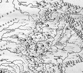
| Mappa Mineralographica | |
|---|---|
| Artist | |
| Title |
Mappa Mineralographica |
| Description |
English: Mining map of Northern Transylvania (Romania). Published in the 1726 work Danubius Pannonico-Mysicus, vol. 2 by the Italian naturalist and soldier Luigi Ferdinando Marsigli (1658 – 1730).
This file was uploaded with Commonist. |
| Date | 1726 |
| Source/Photographer | Morarescu, Codrea (2011) - Informatii mineralogice din secolul 18 dupa Marsigli, Studii si comunicari DIS, vol IV at Romanian Committee for History and Philosophy of Science and Technology, part of Romanian Academy |
| Other versions |
|

| Luigi Ferdinando Marsigli: Danubius Pannonico-Mysicus | |||||||||||||||||||||||||||||||||||||||||||||||||||||
|---|---|---|---|---|---|---|---|---|---|---|---|---|---|---|---|---|---|---|---|---|---|---|---|---|---|---|---|---|---|---|---|---|---|---|---|---|---|---|---|---|---|---|---|---|---|---|---|---|---|---|---|---|---|
| Author |
|
 | |||||||||||||||||||||||||||||||||||||||||||||||||||
| Illustrator |
|
||||||||||||||||||||||||||||||||||||||||||||||||||||
| Title | |||||||||||||||||||||||||||||||||||||||||||||||||||||
| Subtitle | Observationibus geographicis, astronomicis, hydrographicis, historicis, physicis perlustratus | ||||||||||||||||||||||||||||||||||||||||||||||||||||
| Volume | 1–6 | ||||||||||||||||||||||||||||||||||||||||||||||||||||
| Publisher | |||||||||||||||||||||||||||||||||||||||||||||||||||||
| Description |
English: 1726 work by the Italian naturalist and soldier Luigi Ferdinando Marsigli (1658 – 1730). It is a natural history encyclopedia of the lower Danube, published in 6 volumes in both The Hague and Amsterdam. The extensive work covers cartography (vol. 1), classical studies (vol. 2), mineralogy (vol. 3), fish fauna (vol. 4), birds (vol. 5) and other subjects (vol. 6).
Detailed information by volumes:
|
||||||||||||||||||||||||||||||||||||||||||||||||||||
| Language | Latin | ||||||||||||||||||||||||||||||||||||||||||||||||||||
| Publication date | 1726 | ||||||||||||||||||||||||||||||||||||||||||||||||||||
| Place of publication | The Hague and Amsterdam | ||||||||||||||||||||||||||||||||||||||||||||||||||||
| Source | Various, see individual images/pages | ||||||||||||||||||||||||||||||||||||||||||||||||||||
| Permission (Reusing this file) |
|
||||||||||||||||||||||||||||||||||||||||||||||||||||


Licensing edit
|
This work is in the public domain in its country of origin and other countries and areas where the copyright term is the author's life plus 100 years or fewer. | |
| This file has been identified as being free of known restrictions under copyright law, including all related and neighboring rights. | |
File history
Click on a date/time to view the file as it appeared at that time.
| Date/Time | Thumbnail | Dimensions | User | Comment | |
|---|---|---|---|---|---|
| current | 23:53, 17 December 2011 | | 869 × 774 (413 KB) | Codrinb (talk | contribs) |
You cannot overwrite this file.
File usage on Commons
The following 3 pages use this file:
File usage on other wikis
The following other wikis use this file:
- Usage on en.wikipedia.org
- Usage on ja.wikipedia.org
- Usage on sr.wikipedia.org