File:Miramar Peninsula map 1872.jpg
Size of this preview: 402 × 599 pixels. Other resolutions: 161 × 240 pixels | 322 × 480 pixels | 686 × 1,023 pixels.
Original file (686 × 1,023 pixels, file size: 138 KB, MIME type: image/jpeg)
Captions
Captions
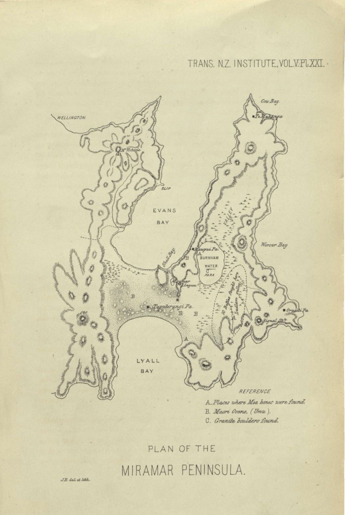
Map drawn for J C Crawford in 1872
Summary edit
| Description |
English: Map of Miramar Peninsula, showing the location of Burnham Water, which was drained between 1848 and 1859. |
| Date | |
| Source | https://paperspast.natlib.govt.nz/periodicals/TPRSNZ1872-5.2.6.1.57 |
| Author | J. B. (probably John Buchanan, who wrote another article in the same issue of the journal) |
Licensing edit
This file is licensed under the Creative Commons Attribution 4.0 International license.
- You are free:
- to share – to copy, distribute and transmit the work
- to remix – to adapt the work
- Under the following conditions:
- attribution – You must give appropriate credit, provide a link to the license, and indicate if changes were made. You may do so in any reasonable manner, but not in any way that suggests the licensor endorses you or your use.
File history
Click on a date/time to view the file as it appeared at that time.
| Date/Time | Thumbnail | Dimensions | User | Comment | |
|---|---|---|---|---|---|
| current | 03:43, 12 April 2024 | | 686 × 1,023 (138 KB) | Wainuiomartian (talk | contribs) | Uploaded a work by J. B. from https://paperspast.natlib.govt.nz/periodicals/TPRSNZ1872-5.2.6.1.57 with UploadWizard |
You cannot overwrite this file.
File usage on Commons
There are no pages that use this file.
File usage on other wikis
The following other wikis use this file:
- Usage on en.wikipedia.org