File:Moldova (1483)-ro.svg

Original file (SVG file, nominally 1,592 × 1,453 pixels, file size: 10.6 MB)
Captions
Captions
|
Summary edit
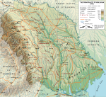
The Moldavian Principality in 1483
| DescriptionMoldova (1483)-ro.svg |
Romana: Creat cu GRASS GIS, The Gimp si Inkscape din urmatoarele date GIS aflate in domeniul public: (SRTM3, SWBD, VMAP0). Vezi si tutorialele cartografice create de Sting - fr:Sting la w:fr:Wikipédia:Atelier graphique/Didacticiels cartographiques/Didacticiels pour la cartographie numérique géoréférencée. Nivelurile de altitudine sunt vectorizate si exportate in format SVG. Umbrele reliefului sunt elemente grafice bitmap integrate in Inkscape. Raurile si malul marii sunt preluate din baza de date GIS VMAP0. Alte referinte: 2. http://cimec.ro/Istorie/neacsu/mijlocMare.jpg Proiectie ortografica cu paralela centrala: 47N si meridian central: 28E. English: Made with GRASS GIS, The Gimp and Inkscape software from public-domain GIS data (SRTM3, SWBD, VMAP0). See the cartographic tutorials by User: Sting - fr:Sting at w:fr:Wikipédia:Atelier graphique/Didacticiels cartographiques/Didacticiels pour la cartographie numérique géoréférencée. Relief levels vectorised and exported to SVG. The relief shading is embedded bitmap graphics. The rivers and shoreline are from VMAP0 GIS database. Additional information from: 2. http://cimec.ro/Istorie/neacsu/mijlocMare.jpg Map projection: Orthographic projection with central parallel: 47N and central meridian 28E. |
| Date | 06-07 March 2009 |
| Source | Own work |
| Author | Andrein |
| Permission (Reusing this file) |
Free use for non-commercial purposes |
| Other versions |
 English version. English version.  PNG Format PNG Format |
| SVG development InfoField | and with QGIS. |
Licensing edit

|
Permission is granted to copy, distribute and/or modify this document under the terms of the GNU Free Documentation License, Version 1.2 or any later version published by the Free Software Foundation; with no Invariant Sections, no Front-Cover Texts, and no Back-Cover Texts. A copy of the license is included in the section entitled GNU Free Documentation License.http://www.gnu.org/copyleft/fdl.htmlGFDLGNU Free Documentation Licensetruetrue |
- You are free:
- to share – to copy, distribute and transmit the work
- to remix – to adapt the work
- Under the following conditions:
- attribution – You must give appropriate credit, provide a link to the license, and indicate if changes were made. You may do so in any reasonable manner, but not in any way that suggests the licensor endorses you or your use.
- share alike – If you remix, transform, or build upon the material, you must distribute your contributions under the same or compatible license as the original.
File history
Click on a date/time to view the file as it appeared at that time.
| Date/Time | Thumbnail | Dimensions | User | Comment | |
|---|---|---|---|---|---|
| current | 11:00, 1 March 2010 |  | 1,592 × 1,453 (10.6 MB) | ArdadN (talk | contribs) | 1 |
| 12:27, 20 February 2010 |  | 1,592 × 1,453 (10.61 MB) | ArdadN (talk | contribs) | 1 | |
| 04:22, 4 April 2009 |  | 1,592 × 1,453 (10.88 MB) | ArdadN (talk | contribs) | 2 | |
| 18:47, 1 April 2009 |  | 1,592 × 1,453 (11.3 MB) | ArdadN (talk | contribs) | 1 | |
| 18:45, 1 April 2009 |  | 1,592 × 1,453 (11.29 MB) | ArdadN (talk | contribs) | 1 | |
| 03:00, 15 March 2009 |  | 2,353 × 2,147 (10.87 MB) | ArdadN (talk | contribs) | 1 | |
| 17:05, 9 March 2009 |  | 2,353 × 2,147 (10.86 MB) | ArdadN (talk | contribs) | htjyu | |
| 16:51, 9 March 2009 |  | 2,353 × 2,147 (9.4 MB) | ArdadN (talk | contribs) | dfcvb | |
| 15:53, 9 March 2009 |  | 2,353 × 2,147 (13.15 MB) | ArdadN (talk | contribs) | 5t6y56u7 | |
| 15:45, 9 March 2009 |  | 2,353 × 2,147 (12.53 MB) | ArdadN (talk | contribs) | Reverted to version as of 15:33, 9 March 2009 |
You cannot overwrite this file.
File usage on Commons
The following 6 pages use this file:
File usage on other wikis
The following other wikis use this file:
- Usage on an.wikipedia.org
- Usage on be-tarask.wikipedia.org
- Usage on ro.wikipedia.org
- Ștefan cel Mare
- Portal:Europa/Imagine
- Principatul Moldovei
- Wikipedia:Propuneri pentru imagini de calitate/Principatul Moldovei in 1483
- Wikipedia:Imagini de calitate/Diagrame, schițe și hărți
- Portal:Europa/Imagine/5
- Utilizator:Memo18/Portal:Europa/Imagine/5
- Moldova
- Zone de operații în Republica Moldova
- Recensământul Moldovei din 1591
- Usage on sq.wikipedia.org
Metadata
This file contains additional information such as Exif metadata which may have been added by the digital camera, scanner, or software program used to create or digitize it. If the file has been modified from its original state, some details such as the timestamp may not fully reflect those of the original file. The timestamp is only as accurate as the clock in the camera, and it may be completely wrong.
| Width | 1592.0336 |
|---|---|
| Height | 1452.6544 |