File:Monthly Climate Normals (1991-2020) - MAIN BAY, AK.svg

Size of this PNG preview of this SVG file: 558 × 516 pixels. Other resolutions: 260 × 240 pixels | 519 × 480 pixels | 831 × 768 pixels | 1,107 × 1,024 pixels | 2,215 × 2,048 pixels.
Original file (SVG file, nominally 558 × 516 pixels, file size: 26 KB)
Captions
Captions
Add a one-line explanation of what this file represents
Summary edit
_-_MAIN_BAY,_AK.svg&action=edit§ion=1)
| Description |
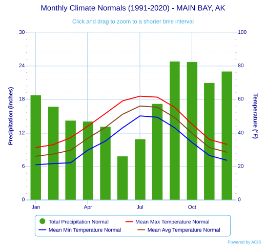
English: Monthly Climate Normals (1991-2020) - MAIN BAY, AK |
| Date | |
| Source | https://www.weather.gov/wrh/Climate?wfo=afc |
| Author | NOAA |
| Camera location | | View this and other nearby images on: OpenStreetMap |
|---|
_-_MAIN_BAY,_AK.svg¶ms=060.518100_N_-148.093000_E_globe:Earth_type:camera__&language=en)
Licensing edit
_-_MAIN_BAY,_AK.svg&action=edit§ion=2)
This image is in the public domain because it contains materials that originally came from the U.S. National Oceanic and Atmospheric Administration, taken or made as part of an employee's official duties.
|
File history
Click on a date/time to view the file as it appeared at that time.
| Date/Time | Thumbnail | Dimensions | User | Comment | |
|---|---|---|---|---|---|
| current | 06:40, 18 June 2023 | | 558 × 516 (26 KB) | Fumikas Sagisavas (talk | contribs) | Uploaded a work by NOAA from https://www.weather.gov/wrh/Climate?wfo=afc with UploadWizard |
You cannot overwrite this file.
File usage on Commons
There are no pages that use this file.
_-_MAIN_BAY,_AK.svg&oldid=804018315)