File:Montserrat aster 3D.png

Size of this preview: 517 × 600 pixels. Other resolutions: 207 × 240 pixels | 563 × 653 pixels.
Original file (563 × 653 pixels, file size: 115 KB, MIME type: image/png)
Captions
Captions
Add a one-line explanation of what this file represents
Summary edit
| Description |
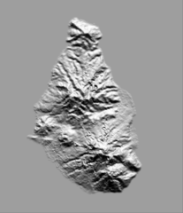
English: Shaded relief image of the island of Montserrat (sun azimuth: 80.0, sun elevation: 15.0). Image produced from a ASTER digital elevation model (DEM) with the GDAL open-source library. Contains residual anomalies and artifacts such as mole runs and pits. Resolution: 1 pixel = 30 meters. Projection: lat/long WGS84. ASTER GDEM is a product of METI and NASA. |
| Date | |
| Source | http://www.gdem.aster.ersdac.or.jp/index.jsp |
| Author | METI and NASA (post-processing by me with the GDAL library) |
- Geographic coordinates: 16°43′55″N 62°11′17″W / 16.732°N 62.188°W
- Reusing this image in a GIS software with a world file: copy/past the next parameters -->
0.0002772783
0.0000000000
0.0000000000
-0.0002777766
-62.2647209167
16.8400001526
Licensing edit
| This file is in the public domain in the United States because it was solely created by NASA. NASA copyright policy states that "NASA material is not protected by copyright unless noted". (See Template:PD-USGov, NASA copyright policy page or JPL Image Use Policy.) | ||
 |
Warnings:
|
| Annotations | This image is annotated: View the annotations at Commons |
File history
Click on a date/time to view the file as it appeared at that time.
| Date/Time | Thumbnail | Dimensions | User | Comment | |
|---|---|---|---|---|---|
| current | 11:46, 16 March 2010 | | 563 × 653 (115 KB) | Barracuda1983 (talk | contribs) | {{Information |Description={{en|1=Shaded relief image of the island of Montserrat. Image produced from a ''ASTER'' digital elevation model (''DEM'') with the ''GDAL'' open-source library (azimuth: 15.0, elevation: 80.0). Contains residual anomalies and ar |
You cannot overwrite this file.
File usage on Commons
The following page uses this file:
- File:Montserrat SRTM 90m.png (file redirect)
File usage on other wikis
The following other wikis use this file:
- Usage on pl.wikipedia.org