File:Morrissey Boulevard.png

Size of this preview: 404 × 599 pixels. Other resolutions: 162 × 240 pixels | 324 × 480 pixels | 518 × 768 pixels | 691 × 1,024 pixels | 1,780 × 2,639 pixels.
Original file (1,780 × 2,639 pixels, file size: 667 KB, MIME type: image/png)
Captions
Captions
Add a one-line explanation of what this file represents
Summary edit
| Description |
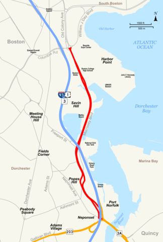
English: Map showing Morrissey Boulevard and surrounding area in Dorchester, Boston, Massachusetts with Morrissey Boulevard highlighted in red. |
| Date | |
| Source | Own work by uploader, using Quantum GIS and Inkscape based on public data from Office of Geographic and Environmental Information (MassGIS), Commonwealth of Massachusetts Executive Office of Environmental Affairs - http://www.mass.gov/mgis/dd-over.htm |
| Author | Sswonk |
| PNG development |
| Camera location | | View this and other nearby images on: OpenStreetMap |
|---|
Licensing edit
I, the copyright holder of this work, hereby publish it under the following license:
This file is licensed under the Creative Commons Attribution-Share Alike 3.0 Unported license.
- You are free:
- to share – to copy, distribute and transmit the work
- to remix – to adapt the work
- Under the following conditions:
- attribution – You must give appropriate credit, provide a link to the license, and indicate if changes were made. You may do so in any reasonable manner, but not in any way that suggests the licensor endorses you or your use.
- share alike – If you remix, transform, or build upon the material, you must distribute your contributions under the same or compatible license as the original.
File history
Click on a date/time to view the file as it appeared at that time.
| Date/Time | Thumbnail | Dimensions | User | Comment | |
|---|---|---|---|---|---|
| current | 03:35, 1 November 2009 | | 1,780 × 2,639 (667 KB) | Sswonk (talk | contribs) | match land color to other state highway maps |
| 03:21, 1 November 2009 |  | 1,780 × 2,639 (665 KB) | Sswonk (talk | contribs) | add labels, tweak label positions | |
| 20:35, 31 October 2009 |  | 1,780 × 2,639 (631 KB) | Sswonk (talk | contribs) | fix streets alpha | |
| 18:49, 31 October 2009 |  | 1,780 × 2,639 (603 KB) | Sswonk (talk | contribs) | fixed framing, added legend | |
| 18:29, 31 October 2009 |  | 3,564 × 2,520 (493 KB) | Sswonk (talk | contribs) | {{Information |Description={{en|1=Map showing en:Morrissey Boulevard and surrounding area in en:Dorchester, Boston, en:Boston, en:Massachusetts with Morrissey Boulevard highlighted in red.}} |Source=Own work by uploader, using Quan |
You cannot overwrite this file.
File usage on Commons
The following page uses this file:
File usage on other wikis
The following other wikis use this file:
- Usage on de.wikipedia.org
- Usage on en.wikipedia.org
- Usage on www.wikidata.org