File:Mount Kenya Population map-en.svg

Size of this PNG preview of this SVG file: 387 × 600 pixels. Other resolutions: 155 × 240 pixels | 310 × 480 pixels | 495 × 768 pixels | 660 × 1,024 pixels | 1,321 × 2,048 pixels | 1,802 × 2,793 pixels.
Original file (SVG file, nominally 1,802 × 2,793 pixels, file size: 1.18 MB)
Captions
Captions
Add a one-line explanation of what this file represents
| Description |
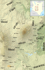
English: Map of the population around Mount Kenya, in English. Français : Carte des peuples habitant la région du Mont Kenya. |
| Date | (UTC) |
| Source | |
| Author |
|
| This is a retouched picture, which means that it has been digitally altered from its original version. Modifications: made an English version. The original can be viewed here: Mount Kenya Population map-fr.svg:
|
I, the copyright holder of this work, hereby publish it under the following licenses:
This file is licensed under the Creative Commons Attribution-Share Alike 3.0 Unported, 2.5 Generic, 2.0 Generic and 1.0 Generic license.
- You are free:
- to share – to copy, distribute and transmit the work
- to remix – to adapt the work
- Under the following conditions:
- attribution – You must give appropriate credit, provide a link to the license, and indicate if changes were made. You may do so in any reasonable manner, but not in any way that suggests the licensor endorses you or your use.
- share alike – If you remix, transform, or build upon the material, you must distribute your contributions under the same or compatible license as the original.

|
Permission is granted to copy, distribute and/or modify this document under the terms of the GNU Free Documentation License, Version 1.2 or any later version published by the Free Software Foundation; with no Invariant Sections, no Front-Cover Texts, and no Back-Cover Texts. A copy of the license is included in the section entitled GNU Free Documentation License. |
You may select the license of your choice.
Original upload log edit
This image is a derivative work of the following images:
- File:Mount_Kenya_Population_map-fr.svg licensed with Cc-by-sa-3.0,2.5,2.0,1.0, GFDL
- 2010-02-28T09:32:57Z Sémhur 1802x2793 (1235875 Bytes) Border removed
- 2008-04-29T19:52:23Z Sémhur 1805x2796 (2604067 Bytes) Wakamba added
- 2008-04-28T20:08:45Z Sémhur 1805x2796 (2614484 Bytes) == Description == {{Information |Description= {{en|Map of the population around the [[:en:Mount Kenya|Mount Kenya]], in french.}} {{fr|Carte des peuples habitant la région du [[:fr:Mont Kenya|Mont Kenya]].}} |Source=travail
Uploaded with derivativeFX
File history
Click on a date/time to view the file as it appeared at that time.
| Date/Time | Thumbnail | Dimensions | User | Comment | |
|---|---|---|---|---|---|
| current | 05:58, 3 March 2010 | | 1,802 × 2,793 (1.18 MB) | Erp (talk | contribs) | {{Information |Description={{en|Map of the population around Mount Kenya, in french.}} {{fr|Carte des peuples habitant la région du Mont Kenya.}} |Source=*File:Mount_Kenya_Population_map-fr.svg |Date=2010-03-0 |
You cannot overwrite this file.
File usage on Commons
There are no pages that use this file.
File usage on other wikis
The following other wikis use this file:
- Usage on af.wikipedia.org
- Usage on bn.wikipedia.org
- Usage on en.wikipedia.org
- Usage on hr.wikipedia.org
- Usage on ja.wikipedia.org
- Usage on ml.wikipedia.org
- Usage on sh.wikipedia.org
- Usage on sl.wikipedia.org