File:Moyen Orient 1600 aC.png
Size of this preview: 800 × 554 pixels. Other resolutions: 320 × 221 pixels | 640 × 443 pixels | 1,024 × 709 pixels | 1,280 × 886 pixels | 1,715 × 1,187 pixels.
Original file (1,715 × 1,187 pixels, file size: 2.56 MB, MIME type: image/png)
Captions
Captions
Add a one-line explanation of what this file represents
| Description |
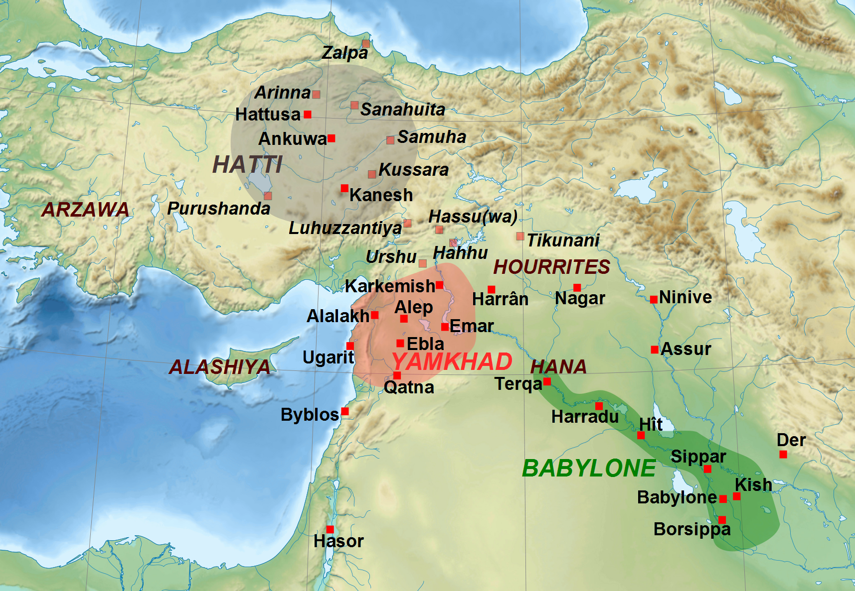
Français : Carte du Moyen-Orient à la fin de la période paléo-babylonienne, c. 1600 av. J.-C. La localisation des sites dont les noms sont en italique et l'extension des royaumes sont approximatives et indicatives. English: Map of the Middle East during the end of the Old Babylonian Period, c. 1600 BC. The location of sites which names are written in italic type and of the extension of the kingdoms are approximate. |
| Date | (UTC) |
| Source | |
| Author |
|
| This is a retouched picture, which means that it has been digitally altered from its original version. Modifications: Conversion png.. The original can be viewed here: Moyen Orient 1600 aC.svg:
|
I, the copyright holder of this work, hereby publish it under the following licenses:
This file is licensed under the Creative Commons Attribution-Share Alike 3.0 Unported, 2.5 Generic, 2.0 Generic and 1.0 Generic license.
- You are free:
- to share – to copy, distribute and transmit the work
- to remix – to adapt the work
- Under the following conditions:
- attribution – You must give appropriate credit, provide a link to the license, and indicate if changes were made. You may do so in any reasonable manner, but not in any way that suggests the licensor endorses you or your use.
- share alike – If you remix, transform, or build upon the material, you must distribute your contributions under the same or compatible license as the original.

|
Permission is granted to copy, distribute and/or modify this document under the terms of the GNU Free Documentation License, Version 1.2 or any later version published by the Free Software Foundation; with no Invariant Sections, no Front-Cover Texts, and no Back-Cover Texts. A copy of the license is included in the section entitled GNU Free Documentation License. |
You may select the license of your choice.
Original upload log edit
This image is a derivative work of the following images:
- File:Moyen_Orient_1600_aC.svg licensed with Cc-by-sa-3.0,2.5,2.0,1.0, GFDL
- 2011-05-15T21:37:41Z Zunkir 1715x1187 (3646362 Bytes) {{Information |Description={{fr|1=Carte du Moyen-Orient à la fin de la période paléo-babylonienne, c. 1600 av. J.-C. La localisation des sites dont les noms sont en italique et l'extension des royaumes sont approximatives
Uploaded with derivativeFX
File history
Click on a date/time to view the file as it appeared at that time.
| Date/Time | Thumbnail | Dimensions | User | Comment | |
|---|---|---|---|---|---|
| current | 21:50, 15 May 2011 | | 1,715 × 1,187 (2.56 MB) | Zunkir (talk | contribs) | Modifications police. |
| 21:41, 15 May 2011 |  | 1,715 × 1,187 (2.56 MB) | Zunkir (talk | contribs) | {{Information |Description={{fr|1=Carte du Moyen-Orient à la fin de la période paléo-babylonienne, c. 1600 av. J.-C. La localisation des sites dont les noms sont en italique et l'extension des royaumes sont approximatives et indicatives.}}{{en|1=Map of |
You cannot overwrite this file.
File usage on Commons
There are no pages that use this file.
File usage on other wikis
The following other wikis use this file:
- Usage on am.wikipedia.org
- Usage on fr.wikipedia.org
- Usage on gl.wikipedia.org
- Usage on it.wikipedia.org
- Usage on pl.wikipedia.org
- Usage on uk.wikipedia.org