File:Mozart in Italy de.svg

Size of this PNG preview of this SVG file: 485 × 599 pixels. Other resolutions: 194 × 240 pixels | 388 × 480 pixels | 621 × 768 pixels | 828 × 1,024 pixels | 1,657 × 2,048 pixels | 568 × 702 pixels.
Original file (SVG file, nominally 568 × 702 pixels, file size: 446 KB)
Captions
Captions
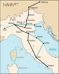
Map of the most important stops on Mozart's first trip to Italy from December 1769 to March 1771. The black line shows the main route from Salzburg to Naples, the blue line shows the route on the return journey.
Summary
edit
| Description |
Deutsch: Karte der wichtigsten Stationen auf Mozarts erster Italienreise Dezember 1769 bis März 1771. Die schwarze Linie zeigt die Hauptroute von Salzburg bis Neapel, die blaue Linie zeigt die Route auf der Rückreise:
Reiseroute Salzburg - Neapel Abweichungen auf der RückrouteEnglish: Map showing main centres visited during first Italian journey, December 1769 to March 1771. The black line shows the main outward route from Salzburg to Naples. The blue line marks detours taken during the return journey. |
||
| Date | (UTC) | ||
| Source |
This file was derived from: Mozart in Italy.svg:  |
||
| Author |
|
||
| SVG development | This W3C-invalid map was created with Adobe Illustrator, and with Inkscape.
|
Licensing
edit
I, the copyright holder of this work, hereby publish it under the following license:
| I, the copyright holder of this work, release this work into the public domain. This applies worldwide. In some countries this may not be legally possible; if so: I grant anyone the right to use this work for any purpose, without any conditions, unless such conditions are required by law. |
Original upload log
edit
This image is a derivative work of the following images:
- File:Mozart in Italy.svg licensed with PD-self
- 2009-03-02T22:47:24Z Jappalang 2279x2811 (451395 Bytes) Converted fonts (objects) to paths
- 2009-01-17T09:41:19Z Jappalang 2279x2811 (326220 Bytes) {{Information |Description={{en|1=Map showing main centres visited during first Italian journey, December 1769 to March 1771. The black line shows the main outward route from Salzburg to Naples. The green line marks detours t
Uploaded with derivativeFX
File history
Click on a date/time to view the file as it appeared at that time.
| Date/Time | Thumbnail | Dimensions | User | Comment | |
|---|---|---|---|---|---|
| current | 20:44, 11 August 2012 | | 568 × 702 (446 KB) | Furfur (talk | contribs) | == {{int:filedesc}} == {{Information |Description={{de|1=Karte der wichtigsten Stationen auf Mozarts erster Italienreise Dezember 1769 bis März 1771. Die schwarze Linie zeigt die Hauptroute von Salzburg bis Neapel, die blaue Linie zeigt die Route auf ... |
You cannot overwrite this file.
File usage on Commons
There are no pages that use this file.
File usage on other wikis
The following other wikis use this file:
- Usage on de.wikipedia.org
- Usage on rm.wikipedia.org