File:MyanmarKayin.png
No higher resolution available.
MyanmarKayin.png (200 × 379 pixels, file size: 9 KB, MIME type: image/png)
Captions
Captions
Add a one-line explanation of what this file represents
Summary edit
| Description |
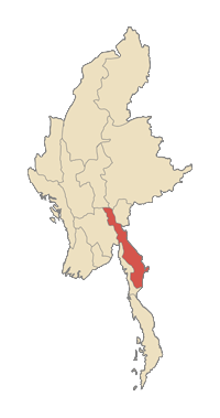
English: Kayin state in Myanmar |
| Date | uploaded to english Wikipedia 4 February 2006 |
| Source | taken from the english Wikipedia |
| Author |

|
File:MyanmarAdministrativeDivisionsKayinState.svg is a vector version of this file. It should be used in place of this PNG file.
File:MyanmarKayin.png → File:MyanmarAdministrativeDivisionsKayinState.svg
For more information, see Help:SVG. |
 |
Licensing edit

|
Permission is granted to copy, distribute and/or modify this document under the terms of the GNU Free Documentation License, Version 1.2 or any later version published by the Free Software Foundation; with no Invariant Sections, no Front-Cover Texts, and no Back-Cover Texts. A copy of the license is included in the section entitled GNU Free Documentation License. |
| This file is licensed under the Creative Commons Attribution-Share Alike 3.0 Unported license. | ||
| ||
| This licensing tag was added to this file as part of the GFDL licensing update. |
File history
Click on a date/time to view the file as it appeared at that time.
| Date/Time | Thumbnail | Dimensions | User | Comment | |
|---|---|---|---|---|---|
| current | 19:40, 19 December 2006 | | 200 × 379 (9 KB) | OHVChris75~commonswiki (talk | contribs) |
You cannot overwrite this file.
File usage on Commons
There are no pages that use this file.
File usage on other wikis
The following other wikis use this file:
- Usage on ace.wikipedia.org
- Usage on de.wikipedia.org
- Usage on el.wikipedia.org
- Usage on en.wikipedia.org
- Manerplaw
- Karen people
- Thandaung
- S'gaw people
- Myawaddy Township
- Kawkareik Township
- Kyain Seikgyi Township
- Hpa-an Township
- Hlaingbwe Township
- Hpapun Township
- Thandaunggyi Township
- Kyainseikgyi
- Kawkareik
- Kyeikdon
- Hlaingbwe
- Papun
- Thandanggyi
- Template:Kayin-geo-stub
- User:Marcus334/Dams in Burma
- Hydropower dams in Myanmar
- Apalon (village)
- Kanni I, Kyain Seikgyi
- Kanni II, Kyain Seikgyi
- Mela Taung
- Nattaung
- Mount Mulayit
- Hpapun District
- Peinhneseik
- Peinnegon, Kayin State
- User talk:Somohto
- Kaingdaw
- Paya-ngokto
- Paya, Kyain Seikgyi
- Katokkra
- Akalaw
- Ywathit, Kyain Seikgyi
- Mount Zwegabin
- To-kawko
- User:Htinanshee/sandbox
- User talk:Kronwa/sandbox
- User:Kronwa/sandbox
- User talk:Kronwa
- Mount Gaungphat
- Kyondoe
- Mount Taungnyo
- User:Foldergallery/sandbox
- Alantaya Taungdan
View more global usage of this file.