File:Myanmar tmo 2019227 lrg.jpg

Original file (3,648 × 3,289 pixels, file size: 2.34 MB, MIME type: image/jpeg)
Captions
Captions
Summary edit
| Description |
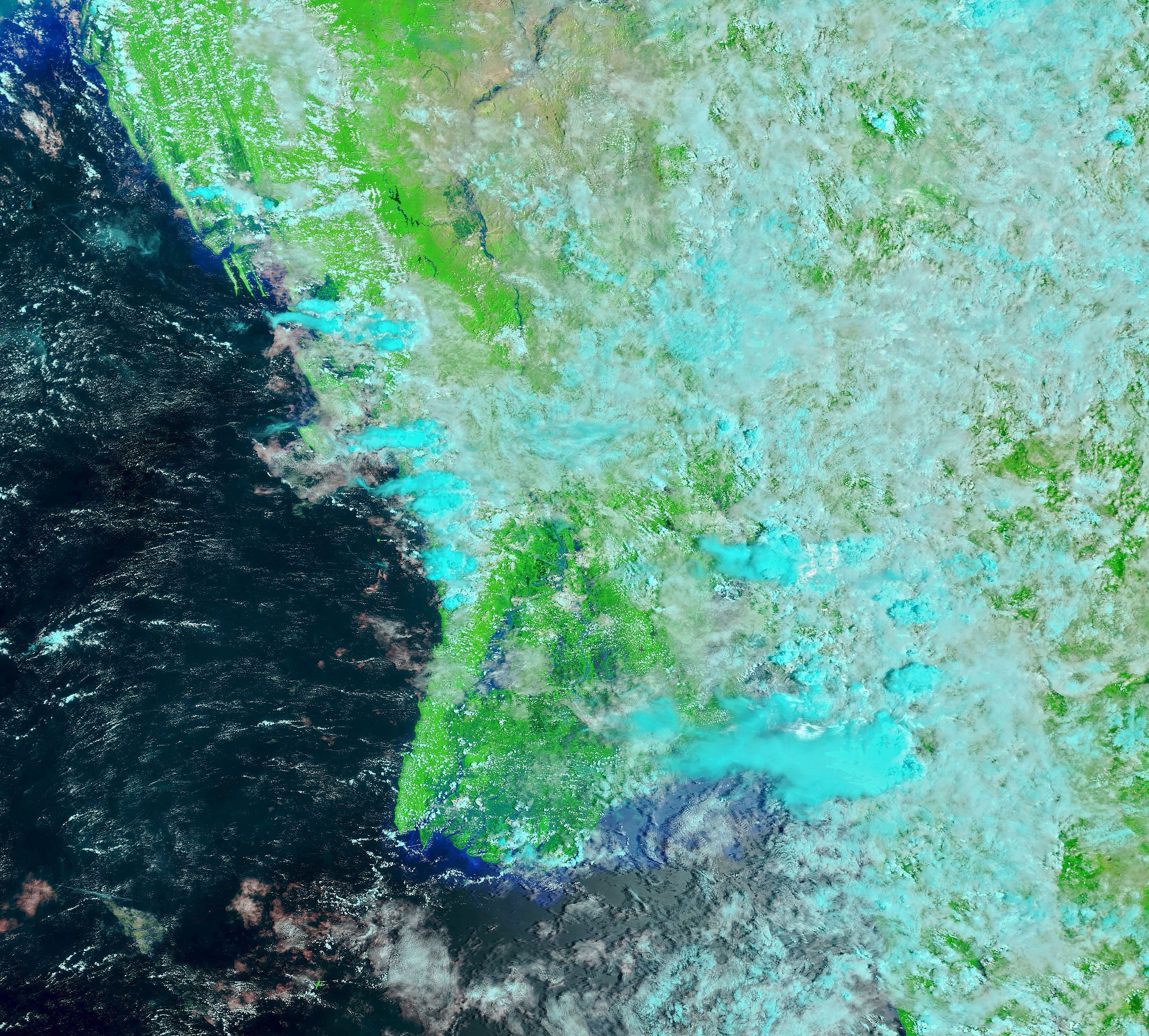
English: Several weeks of heavy monsoon rains in August 2019 swamped Burma (Myanmar) and southern and western India, unleashing destructive floods and landslides. Above-average monsoon rainfall caused rivers and streams to overflow their banks, while destabilizing hillsides in several regions.
The annual monsoon in south Asia typically has its greatest impact between July and September. India, for instance, receives roughly 70 percent of its annual rainfall from the monsoon. The rain is critical for replenishing freshwater supplies and for watering crops. But with at least 15 percent of the country prone to floods, the monsoon also leads to several thousand deaths each year. The false-color images at the top of this page reveal flood conditions in Burma (Myanmar) through cloudy skies in one of the few NASA satellite views of that land surface this view. The images were acquired by the Moderate Resolution Imaging Spectroradiometer (MODIS) on NASA’s Terra satellite on April 2 (left) and August 15, 2019 (right). They were composed from a combination of visible and infrared light (MODIS bands 7-2-1) to distinguish water on the land surface (blue and navy) from clouds (white and teal). In Burma (Myanmar), a landslide took the lives of at least 60 people on August 9. The UN Office for the Coordination of Humanitarian Affairs reported that more than 80,000 people have been moved to emergency shelters amid widespread flooding. In India, the worst of the flooding hit the western and southern states of Kerala, Karnataka, Maharashtra, and Gujarat. Several hundred people have died, and more than a million have been displaced. Flood waters have damaged roads and rail lines in several areas, and destroyed thousands of hectares of summer crops. The India Meteorological Department reported to media that the country received 45 percent more rainfall than average for the week of August 7–14. However, overall rainfall for the 2019 monsoon (starting June 1) is only 1 percent above the 50-year average.Deutsch: Mehrere Wochen schwerer Monsunregenfälle uberschwemmten im August 2019 Myanmar sowie den Süden und Westen Indiens; sie setzten zerstörerische Überflutungen und Erdrutsche in Gang. Überdurchschnittliche Monsunegenmengen führten dazu, dass Flüsse und Ströme ihre Ufer überstiegen und in verschiedenen Regionen Bergflanken destabilisiert wurden.
Die jährliche Monsunsaison in Südasien hat üblicherweise ihre stärksten Auswirkungen zwischen Juli und September. India beispielsweise erhält ungefähr 70 Prozent des jährlichen Regens aus dem Mnsun. Der Monsunregen ist wichtig zum Wiederauffüllen der Süßwasservorräte und zur Bewässerung der Feldfrüchte. Weil allerdings mindestens 15 Prozent des Landes überschwemmungsgefährdet sind, verursacht der Monsun jedes Jahr bis zu mehreren Tausend Toten. Das Falschfarbenbild auf dieser Seite zeigt die Überschwemmungsgebiete in Myanmar durch darüberliegende Wolken hindurch. Die vergleichenden Bilder wurden angefertigt mit dem Moderate Resolution Imaging Spectroradiometer (MODIS) auf dem Terra-Satelliten der NASA – am 2. April und am 15. August 2019. Sie entstanden duch Kmbinationen von sichtbarem und infraroten Licht (MODIS-Bänder 7-2-1), um Wasser auf der Oberfläche (blau und marineblau) von Wolken (weiß und blaugrün). In Burma (Myanmar) kamen durch einen Erdrutsch am 9. August 2019 mindestens 60 Personen um. Das UN Office for the Coordination of Humanitarian Affairs (w:Nothilfekoordinator der Vereinten Nationen, OCHA) meldete, daß wegen ausgedehnter Überschwemmungen mehr als 80.000 Personen in Notunterkünfte gebracht wurden. In Indien waren die südlichen und westlichen Bundesstaaten Kerala, Karnataka, Maharashtra und Gujarat am stärksten von den Überschwemmungen betroffen. Mehrere Hundert Personen kamen um, und mehr als eine Million Menschen mussten fliehen. Die Überflungen haben verschiedentlich Straßen und Bahnstrecken beschädigt und tausende von Hektar Anbauflächen von Sommerfeldfrüchten vernichtet. Das India Meteorological Department teilte den Medien mit, daß Indien in der Woche vom 7. bis 14. August 45 Prozent mehr Niederschläge verzeichnete als im langjährigen Mittel. Die Niederschläge für den diesjährigen Monsun insgesant seit dem 1. Juni liegen allerdings nur 1 Prozent übe dem 50-jährigen Durchschnitt. |
| Date | |
| Source | https://earthobservatFebruaryory.nasa.gov/images/145460/heavy-monsoon-rains-flood-south-asia |
| Author | NASA Earth Observatory image by Joshua Stevens, using MODIS data from NASA EOSDIS/LANCE and GIBS/Worldview. Story by Michael Carlowicz. |
| Other versions |
 2 April 2019 low resolution, labeled  15 August 2019 high resolution, not labeled  15 August 2019 low resolution, labeled |
References & Resources edit
- Al Jazeera (2019, August 14) India floods, landslides kill more than 270. Accessed August 15, 2019.
- Al Jazeera (2019, August 14) Death toll in Myanmar landside rises as rescue efforts continue. Accessed August 15, 2019.
- BBC (2019, August 13) Myanmar landslide death toll rises to 59. Accessed August 15, 2019.
- India Today (2019, August 14) Monsoon Updates: Congress demands complete loan waiver for Maharashtra flood-hit farmers. Accessed August 15, 2019.
- The Guardian (2019, August 14) India issues new flood alert as monsoon death toll reaches 244. Accessed August 15, 2019.
- Thomson Reuters (2019, August 14) India gets above-average monsoon rains for third straight week—weather office. Accessed August 15, 2019.
- Times of India (2019, August 14) Why floods continue to cause so much damage in India. Accessed August 15, 2019.
- Voice of America (2019, August 12) Tens of Thousands Flee Homes in Flood-Hit Myanmar as Landslide Toll Hits 59. Accessed August 15, 2019.
Licensing edit
| This file is in the public domain in the United States because it was solely created by NASA. NASA copyright policy states that "NASA material is not protected by copyright unless noted". (See Template:PD-USGov, NASA copyright policy page or JPL Image Use Policy.) | ||
 |
Warnings:
|
File history
Click on a date/time to view the file as it appeared at that time.
| Date/Time | Thumbnail | Dimensions | User | Comment | |
|---|---|---|---|---|---|
| current | 20:48, 22 August 2019 | | 3,648 × 3,289 (2.34 MB) | Matthiasb (talk | contribs) | {{Information |description ={{en|1=Several weeks of heavy monsoon rains in August 2019 swamped Burma (Myanmar) and southern and western India, unleashing destructive floods and landslides. Above-average monsoon rainfall caused rivers and streams to overflow their banks, while destabilizing hillsides in several regions. The annual monsoon in south Asia typically has its greatest impact between July and September. India, for instance, receives roughly 70 percent of its annual rainfall from t... |
You cannot overwrite this file.
File usage on Commons
The following 4 pages use this file: