File:NCVP map.png
No higher resolution available.
NCVP_map.png (480 × 504 pixels, file size: 162 KB, MIME type: image/png)
Captions
Captions
Add a one-line explanation of what this file represents
Summary edit
| Description |
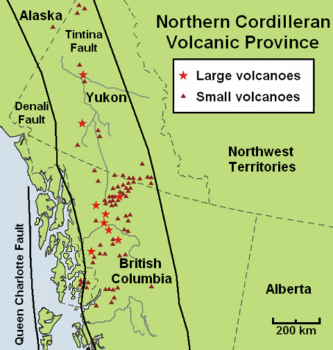
English: Map of minor and major volcanoes of the Northern Cordilleran Volcanic Province in northwestern North America. |
| Date | |
| Source | Own work based on volcano information on the Geological Survey of Canada website ([1]). Fault lines are taken from [2] |
| Author | Black Tusk |
Licensing edit
I, the copyright holder of this work, hereby publish it under the following license:
This file is licensed under the Creative Commons Attribution 3.0 Unported license.
- You are free:
- to share – to copy, distribute and transmit the work
- to remix – to adapt the work
- Under the following conditions:
- attribution – You must give appropriate credit, provide a link to the license, and indicate if changes were made. You may do so in any reasonable manner, but not in any way that suggests the licensor endorses you or your use.
File history
Click on a date/time to view the file as it appeared at that time.
| Date/Time | Thumbnail | Dimensions | User | Comment | |
|---|---|---|---|---|---|
| current | 23:33, 13 October 2009 | | 480 × 504 (162 KB) | Black Tusk (talk | contribs) | {{Information |Description={{en|1=Map of minor and major volcanoes of the Northern Cordilleran Volcanic Province in northwestern North America.}} |Source={{own}} |Author=Black Tusk |Date=October 13, 2009 |Permission=See below |other_ve |
You cannot overwrite this file.
File usage on Commons
There are no pages that use this file.
File usage on other wikis
The following other wikis use this file:
- Usage on en.wikipedia.org
- Usage on fr.wikipedia.org