File:NRHP Minnesota Map.svg

Size of this PNG preview of this SVG file: 463 × 599 pixels. Other resolutions: 185 × 240 pixels | 371 × 480 pixels | 593 × 768 pixels | 791 × 1,024 pixels | 1,582 × 2,048 pixels | 765 × 990 pixels.
Original file (SVG file, nominally 765 × 990 pixels, file size: 12.47 MB)
Captions
Captions
Add a one-line explanation of what this file represents
Summary edit
| Description |
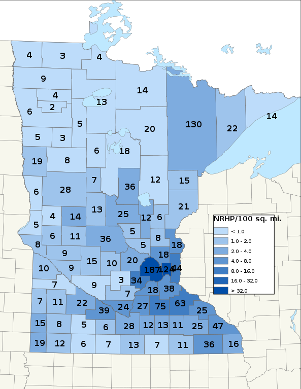
English: Map of NRHP sites per 100 sq. miles, by county. Data as of April 11, 2022
|
||
| Date | 7/5/09 (created) | ||
| Source | Own work | ||
| Author | 25or6to4 |
Licensing edit
I, the copyright holder of this work, hereby publish it under the following licenses:
This file is licensed under the Creative Commons Attribution-Share Alike 3.0 Unported license.
- You are free:
- to share – to copy, distribute and transmit the work
- to remix – to adapt the work
- Under the following conditions:
- attribution – You must give appropriate credit, provide a link to the license, and indicate if changes were made. You may do so in any reasonable manner, but not in any way that suggests the licensor endorses you or your use.
- share alike – If you remix, transform, or build upon the material, you must distribute your contributions under the same or compatible license as the original.

|
Permission is granted to copy, distribute and/or modify this document under the terms of the GNU Free Documentation License, Version 1.2 or any later version published by the Free Software Foundation; with no Invariant Sections, no Front-Cover Texts, and no Back-Cover Texts. A copy of the license is included in the section entitled GNU Free Documentation License. |
You may select the license of your choice.
File history
Click on a date/time to view the file as it appeared at that time.
| Date/Time | Thumbnail | Dimensions | User | Comment | |
|---|---|---|---|---|---|
| current | 07:54, 11 April 2022 | | 765 × 990 (12.47 MB) | 25or6to4 (talk | contribs) | Updated through March 2022 |
| 10:01, 23 March 2019 |  | 765 × 990 (4.14 MB) | 25or6to4 (talk | contribs) | Updated through March 1, 2019. | |
| 17:34, 3 April 2016 |  | 612 × 792 (1.35 MB) | 25or6to4 (talk | contribs) | Updated through January 1, 2016 | |
| 17:58, 15 September 2014 |  | 612 × 792 (1.32 MB) | 25or6to4 (talk | contribs) | Updated through September 2014 | |
| 07:16, 16 September 2012 |  | 792 × 612 (421 KB) | 25or6to4 (talk | contribs) | updated through August 2012 | |
| 23:39, 24 December 2009 |  | 612 × 792 (386 KB) | 25or6to4 (talk | contribs) | Updated through 12/18/09 | |
| 06:47, 6 July 2009 |  | 765 × 990 (772 KB) | 25or6to4 (talk | contribs) | text test | |
| 06:28, 6 July 2009 |  | 765 × 990 (772 KB) | 25or6to4 (talk | contribs) | font fix | |
| 06:25, 6 July 2009 |  | 765 × 990 (768 KB) | 25or6to4 (talk | contribs) | {{Information |Description={{en|1=Map of NRHP sites per 100 sq. miles, by county. Data as of July 2, 2009}} |Source=Own work by uploader |Author=25or6to4 |Date=7/5/09 |Permission= |other_versions= }} <!--{{ImageUpload|full}}--> [[Categ |
You cannot overwrite this file.
File usage on Commons
There are no pages that use this file.
File usage on other wikis
The following other wikis use this file:
- Usage on de.wikipedia.org
- Usage on en.wikipedia.org
- Usage on pt.wikipedia.org
- Usage on ro.wikipedia.org
- Minnesota
- Format:Minnesota stat SUA
- Categorie:Statul Minnesota, SUA
- Saint Paul, Minnesota
- Categorie:Formate Minnesota
- Categorie:Liste Minnesota
- Categorie:Comitate din statul Minnesota, SUA
- Categorie:Lacuri din Minnesota
- Listă de oameni din statul Minnesota
- Categorie:Guvernul statului Minnesota
- Listă de comitate din statul Minnesota
- Categorie:Sedii de comitate din Minnesota
- Categorie:Zone metropolitane din Minnesota
- Categorie:Zone micropolitane din Minnesota
- Categorie:Localități din Minnesota
- Categorie:Forme de relief din Minnesota
- Categorie:Comitatul Houston, Minnesota
- Categorie:Regiuni ale statului Minnesota
- Categorie:Comitatul Aitkin, Minnesota
- Categorie:Comitatul Anoka, Minnesota
- Categorie:Comitatul Beltrami, Minnesota
- Categorie:Comitatul Ramsey, Minnesota
- Categorie:Saint Paul, Minnesota
- Categorie:Dezastre naturale din statul Minnesota
- Bemidji, Minnesota
- Comitatul Saint Louis, Minnesota
- Rochester, Minnesota
- Comitatul Olmsted, Minnesota
- Categorie:Membri ai legislaturii statului Minnesota
- Categorie:Localități din comitatul Olmsted, Minnesota
- Categorie:Geografia statului Minnesota după comitat
- Categorie:Localități din comitatul Ramsey, Minnesota
- Categorie:Absolvenți din Minnesota după instituția de învățământ superior
- Categorie:Geologia statului Minnesota
- Categorie:Oameni din statul Minnesota după ocupație
- Categorie:Localități din statul Minnesota riverane fluviului Mississippi
- Categorie:Localități din comitatul Beltrami, Minnesota
- Categorie:Geografia comitatului Beltrami, Minnesota
- Categorie:Geografia comitatului Olmsted, Minnesota
- Categorie:Geografia comitatului Ramsey, Minnesota
- Categorie:Târguri din statul Minnesota
- Categorie:Municipalități din statul Minnesota
- Categorie:Insule ale statului Minnesota
- Categorie:Locuri desemnate pentru recensământ din statul Minnesota
- Categorie:Subdiviziunile statului Minnesota
- Categorie:Istoria naturală a statului Minnesota
- Categorie:Dezastre din statul Minnesota
View more global usage of this file.