File:NT small bushfires July 2019.jpg

Size of this preview: 800 × 450 pixels. Other resolutions: 320 × 180 pixels | 640 × 360 pixels | 1,024 × 576 pixels | 1,280 × 720 pixels | 1,920 × 1,080 pixels.
Original file (1,920 × 1,080 pixels, file size: 1.45 MB, MIME type: image/jpeg)
Captions
Captions
Add a one-line explanation of what this file represents
Summary edit
| Description |
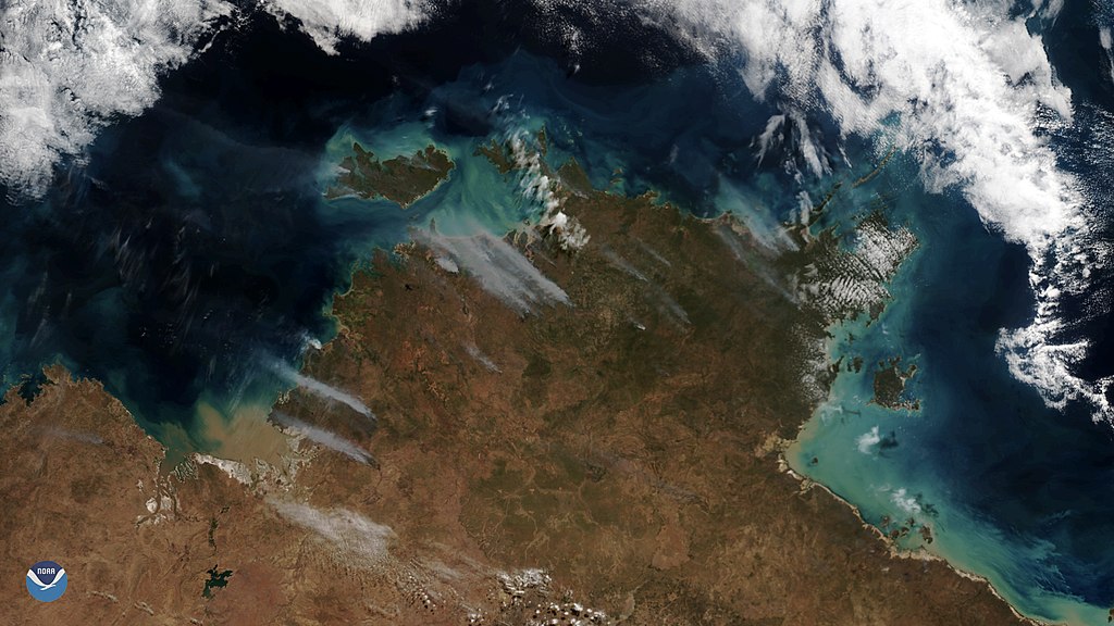
English: Clear skies over Australia on July 16, 2019, gave the NOAA-20 polar-orbiting satellite an unobstructed view of smoke plumes from bushfires across the Northern Territory. The bushfire season started early across parts of northern Australia, which experts with the Bushfire and Natural Hazards Cooperative Research Centre attribute to record warmth and below-average rainfall. |
| Date | |
| Source | https://www.nesdis.noaa.gov/content/noaa-20-sees-plumes-smoke-bushfires |
| Author | NOAA / NESDIS |
Licensing edit
This image is in the public domain because it contains materials that originally came from the U.S. National Oceanic and Atmospheric Administration, taken or made as part of an employee's official duties.
|
File history
Click on a date/time to view the file as it appeared at that time.
| Date/Time | Thumbnail | Dimensions | User | Comment | |
|---|---|---|---|---|---|
| current | 08:16, 6 January 2020 | | 1,920 × 1,080 (1.45 MB) | A1Cafel (talk | contribs) | User created page with UploadWizard |
You cannot overwrite this file.
File usage on Commons
The following 21 pages use this file:
- Commons:WikiProject Aviation/recent uploads/2020 January 6
- Category:Airports in the Northern Territory
- Category:Beaches of the Northern Territory
- Category:Births in the Northern Territory
- Category:Bridges in the Northern Territory
- Category:Deaths in the Northern Territory
- Category:Highways in the Northern Territory
- Category:Hospitals in the Northern Territory
- Category:Lakes of the Northern Territory
- Category:Lighthouses in the Northern Territory
- Category:Local government in the Northern Territory
- Category:Mountains of the Northern Territory
- Category:Northern Territory
- Category:People of the Northern Territory
- Category:Rail transport in the Northern Territory
- Category:Railway lines in the Northern Territory
- Category:Railway museums in the Northern Territory
- Category:Roads in the Northern Territory
- Category:Storms in the Northern Territory
- Category:Train stations in the Northern Territory
- Category:Zoos in the Northern Territory
File usage on other wikis
The following other wikis use this file:
- Usage on ar.wikipedia.org
- Usage on ary.wikipedia.org
- Usage on arz.wikipedia.org
- Usage on ast.wikipedia.org
- Usage on az.wikipedia.org
- Usage on ca.wikipedia.org
- Usage on cs.wikipedia.org
- Usage on cy.wikipedia.org
- Usage on de.wikivoyage.org
- Usage on diq.wikipedia.org
- Usage on en.wikivoyage.org
- Usage on eu.wikipedia.org
- Usage on fi.wikipedia.org
- Usage on fr.wikivoyage.org
- Usage on ga.wikipedia.org
- Usage on gl.wikipedia.org
- Usage on hy.wikipedia.org
- Usage on mzn.wikipedia.org
- Usage on nn.wikipedia.org
- Usage on no.wikipedia.org
- Usage on oc.wikipedia.org
- Usage on os.wikipedia.org
- Usage on pl.wikipedia.org
- Usage on ps.wikipedia.org
- Usage on ro.wikipedia.org
- Usage on ru.wikipedia.org
- Usage on tl.wikipedia.org
- Usage on uk.wikipedia.org
- Usage on vec.wikipedia.org
- Usage on www.wikidata.org