File:NWS preliminary information and track map for the Lewisburg EF0 tornado on January 22, 2024.jpg

Size of this preview: 800 × 495 pixels. Other resolutions: 320 × 198 pixels | 640 × 396 pixels | 1,024 × 633 pixels | 1,280 × 792 pixels | 2,257 × 1,396 pixels.
Original file (2,257 × 1,396 pixels, file size: 1.08 MB, MIME type: image/jpeg)
Captions
Captions
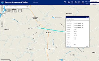
NWS preliminary information and track map for the Lewisburg EF0 tornado on January 22, 2024
Summary edit
| Description |
English: Preliminary information from the National Weather Service on an EF0 tornado north of Lewisburg, Kentucky on January 22, 2024. According to the National Weather Service, the tornado traveled with an average forward speed of 176.4 miles per hour (283.9 km/h). |
| Date | |
| Source | NOAA Damage Assessment Toolkit: https://apps.dat.noaa.gov/stormdamage/damageviewer/ |
| Author | National Weather Service office in Louisville, Kentucky |
Licensing edit
This image is in the public domain because it contains materials that originally came from the U.S. National Oceanic and Atmospheric Administration, taken or made as part of an employee's official duties.
|
File history
Click on a date/time to view the file as it appeared at that time.
| Date/Time | Thumbnail | Dimensions | User | Comment | |
|---|---|---|---|---|---|
| current | 07:54, 29 January 2024 | | 2,257 × 1,396 (1.08 MB) | WeatherWriter (talk | contribs) | Uploaded a work by National Weather Service office in Louisville, Kentucky from NOAA Damage Assessment Toolkit: https://apps.dat.noaa.gov/stormdamage/damageviewer/ with UploadWizard |
You cannot overwrite this file.
File usage on Commons
There are no pages that use this file.