File:Nameless Figure 4.jpg
Nameless_Figure_4.jpg (277 × 371 pixels, file size: 22 KB, MIME type: image/jpeg)
Captions
Captions
Summary edit
| Author |
|
||||||||||||||||||||||||||
| Description |
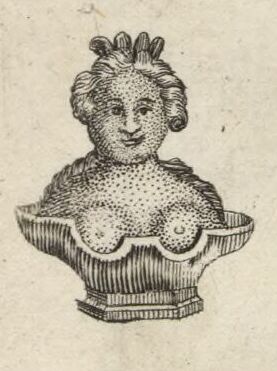
English: A depiction of a bust discovered in 1714 in the Southbroom Hoard near Devizes, Wiltshire, from the figures decorating the margins of Moll's map of "Hamp Shire" (Hampshire), the eighth in his Set of Fifty New and Correct Maps of England and Wales... The figure was actually part of the Southbroom Hoard discovered near Devizes, Wiltshire, in 1714 but placed on the Hampshire map for want of room. Moll copied the figure's appearance and lack of identification from Musgrave's 1719 account of the hoard.
Français : Sujet : Antiquités romaines
Monnaies Divisions politiques et administratives Hampshire, Comté du -- Divisions politiques et administratives Échelle(s) : 6 English Miles [= 2,6 cm] Référence bibliographique : 173 Appartient à l’ensemble documentaire : AnvilEur Appartient à l’ensemble documentaire : MAEDI008 Appartient à l’ensemble documentaire : MAEDIGen0 Couverture : Royaume-Uni – Angleterre – Hampshire Langue : anglais |
||||||||||||||||||||||||||
| Date | 1724 | ||||||||||||||||||||||||||
| Dimensions | Full page: height: 35 cm (13.7 in); width: 23.5 cm (9.2 in) | ||||||||||||||||||||||||||
| Collection |
|
||||||||||||||||||||||||||
| References |
Français : Notice de recueil : http://catalogue.bnf.fr/ark:/12148/cb40577015h
Appartient à : Collection d'Anville ; 02107 Notice du catalogue : http://catalogue.bnf.fr/ark:/12148/cb412471989 |
||||||||||||||||||||||||||
| Source/Photographer |
Français : Bibliothèque nationale de France, département Cartes et plans, GE DD-2987 (2107)
Bibliothèque nationale de France |
||||||||||||||||||||||||||
| Permission (Reusing this file) |
|
||||||||||||||||||||||||||
| Other versions |
|
||||||||||||||||||||||||||


.jpg)
File history
Click on a date/time to view the file as it appeared at that time.
| Date/Time | Thumbnail | Dimensions | User | Comment | |
|---|---|---|---|---|---|
| current | 05:04, 3 June 2023 | | 277 × 371 (22 KB) | LlywelynII (talk | contribs) | File:Hamp Shire - By H. Moll Geographer - btv1b530564887.jpg cropped using CropTool. |
You cannot overwrite this file.
File usage on Commons
The following 4 pages use this file: