File:Nansen Franz Josef Land voyage map-fr.svg

Size of this PNG preview of this SVG file: 599 × 437 pixels. Other resolutions: 320 × 233 pixels | 640 × 467 pixels | 1,024 × 747 pixels | 1,280 × 934 pixels | 2,560 × 1,868 pixels.
Original file (SVG file, nominally 599 × 437 pixels, file size: 200 KB)
Captions
Captions
Add a one-line explanation of what this file represents
Summary edit
| Description |
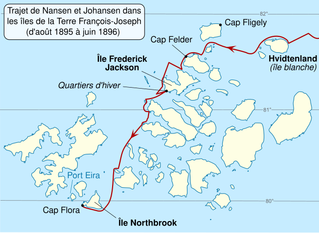
English: Map of Franz Josef Land archipelago in the Arctic Ocean north of Russia, showing the path of Nansen and Johansen through the islands, August 1895 to June 1896. Français : Carte du trajet de l'expédition Fram de Nansen et Johansen à travers les îles de la Terre François-Joseph, d'août 1895 à juin 1896. |
||
| Date | |||
| Source |
Own work. Source :
|
||
| Author |
|
||
| Other versions | |||
| Attribution (required by the license) | © Sémhur / Wikimedia Commons / | ||
| SVG | W3C-validity not checked.
|
||
| Graphic Lab |

| Camera location | | View this and other nearby images on: OpenStreetMap |
|---|
Licensing edit
I, the copyright holder of this work, hereby publish it under the following licenses:
| Copyleft: This work of art is free; you can redistribute it and/or modify it according to terms of the Free Art License. You will find a specimen of this license on the Copyleft Attitude site as well as on other sites. |
This file is licensed under the Creative Commons Attribution-Share Alike 4.0 International, 3.0 Unported, 2.5 Generic, 2.0 Generic and 1.0 Generic license.
- You are free:
- to share – to copy, distribute and transmit the work
- to remix – to adapt the work
- Under the following conditions:
- attribution – You must give appropriate credit, provide a link to the license, and indicate if changes were made. You may do so in any reasonable manner, but not in any way that suggests the licensor endorses you or your use.
- share alike – If you remix, transform, or build upon the material, you must distribute your contributions under the same or compatible license as the original.
You may select the license of your choice.
Original upload log edit
This image is a derivative work of the following images:
- File:Nansen_Franz_Josef_Land_voyage_map.svg licensed with PD-self
- 2009-10-17T23:17:06Z Niagara 600x438 (409529 Bytes) darken latitude lines
- 2009-10-13T01:33:24Z Niagara 600x438 (410724 Bytes) == Summary == {{Information |Description = Map of [[w:Franz Josef Land|Franz Josef Land]] archipelago in the [[w:Arctic Ocean|Arctic Ocean]] north of [[w:Russia|Russia]], showing the path of Nansen and Johansen through the is
Uploaded with derivativeFX
File history
Click on a date/time to view the file as it appeared at that time.
| Date/Time | Thumbnail | Dimensions | User | Comment | |
|---|---|---|---|---|---|
| current | 10:26, 4 July 2011 | | 599 × 437 (200 KB) | Sémhur (talk | contribs) | == {{int:filedesc}} == {{Information |Description={{Multilingual description |en= Map of Franz Josef Land archipelago in the Arctic Ocean north of Russia, showing the path of Nansen and Johansen |
You cannot overwrite this file.
File usage on Commons
There are no pages that use this file.
File usage on other wikis
The following other wikis use this file:
- Usage on fr.wikipedia.org