File:Nargis rain 27apr-4may2008 by TRMM fr.jpg
Size of this preview: 800 × 507 pixels. Other resolutions: 320 × 203 pixels | 640 × 406 pixels | 1,024 × 649 pixels | 1,280 × 811 pixels | 1,800 × 1,141 pixels.
Original file (1,800 × 1,141 pixels, file size: 258 KB, MIME type: image/jpeg)
Captions
Captions
Add a one-line explanation of what this file represents
Summary edit
| Description |
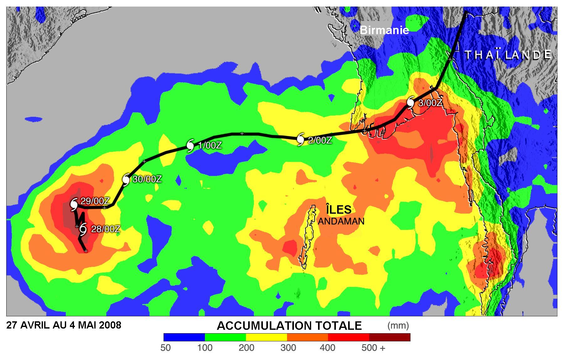
English: Estimate of rainfall with Cyclone Nargis 27 April to 4th of May 2008 according to TRMM weather satellite. Area covered of Bay of Bengal to Burma/Thailand coasts.
Français : Estimé des quantités de pluie tombées avec le Cyclone nargis entre le 27 avril et le 4 mai 2008 selon les données du satellite TRMM. Couverture des pluies sur le Golfe du Bengale, la Birmanie et la Thaïlande |
| Date | |
| Source | NASA TRMM satellite |
| Author | NASA, translated in French by Pierre_cb |
| Other versions | Image:Nargis_rain_27apr-4may2008_by_TRMM.jpg (English original version |
Licensing edit
| This file is in the public domain in the United States because it was solely created by NASA. NASA copyright policy states that "NASA material is not protected by copyright unless noted". (See Template:PD-USGov, NASA copyright policy page or JPL Image Use Policy.) | ||
 |
Warnings:
|
File history
Click on a date/time to view the file as it appeared at that time.
| Date/Time | Thumbnail | Dimensions | User | Comment | |
|---|---|---|---|---|---|
| current | 23:47, 7 June 2008 | | 1,800 × 1,141 (258 KB) | Pierre cb (talk | contribs) | == Description == {{Information |Description={{en|1=Estimate of rainfall with Cyclone Nargis 27 April to 4th of May 2008 according to TRMM weather satellite. Area covered of Bay of Bengal to Burma/Thailand coasts.}} {{fr|1=Estimé des quantités de pluie |
You cannot overwrite this file.
File usage on Commons
There are no pages that use this file.
File usage on other wikis
The following other wikis use this file:
- Usage on fr.wikipedia.org