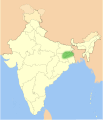
File:Nepenthes khasiana distribution.gif

Size of this preview: 514 × 600 pixels. Other resolutions: 206 × 240 pixels | 515 × 601 pixels.
Original file (515 × 601 pixels, file size: 26 KB, MIME type: image/gif)
File information
Structured data
Captions
Captions
Add a one-line explanation of what this file represents
Summary
editMap showing distribution of Nepenthes khasiana.
Distribution:
- isolated pocket in north-east India
Map colours:
- Light yellow = Territory administered by India (undisputed)
- Yellowish-orange = Administered by India. Claimed by China/Pakistan
- Orangish-Yellow = Administered by China/Pakistan. Claimed by India
- Orange = Neighbouring countries
Based on Nichalp's blank map of India
Licensing
edit| Public domainPublic domainfalsefalse |
| I, the copyright holder of this work, release this work into the public domain. This applies worldwide. In some countries this may not be legally possible; if so: I grant anyone the right to use this work for any purpose, without any conditions, unless such conditions are required by law. |
File history
Click on a date/time to view the file as it appeared at that time.
| Date/Time | Thumbnail | Dimensions | User | Comment | |
|---|---|---|---|---|---|
| current | 01:50, 10 May 2006 |  | 515 × 601 (26 KB) | NepGrower (talk | contribs) | |
| 01:08, 10 May 2006 |  | 516 × 601 (26 KB) | NepGrower (talk | contribs) | == Summary == Map showing distribution of ''Nepenthes khasiana''. '''Distribution:''' * isolated pocket in north-east India '''Map colours:''' * Light yellow = Kalimantan (Indonesia) * Light Orange = Sarawak and Sabah (Malaysia) * Green = Brunei Bas |
You cannot overwrite this file.
File usage on Commons
There are no pages that use this file.