File:Netherlands, Kagerplassen, map of 1617.jpg

Size of this preview: 800 × 503 pixels. Other resolutions: 320 × 201 pixels | 640 × 402 pixels | 1,024 × 644 pixels | 1,280 × 805 pixels | 2,560 × 1,610 pixels | 6,494 × 4,083 pixels.
Original file (6,494 × 4,083 pixels, file size: 10.1 MB, MIME type: image/jpeg)
Captions
Captions
Add a one-line explanation of what this file represents
Summary edit
| Description |
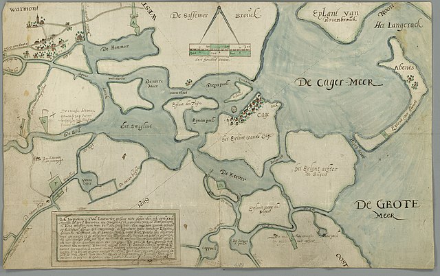
Nederlands: Kaart van de Kagerplassen uit 1617. (Archiefbeschrijving: Kaart van zekere landen, gelegen onder Warmond en Alkemade, toebehorende aan zekere vicarie, gefondeerd op St. Catrijnen altaar te Warmond ten verzoeke van de toenmalige possesseur heer Pouwels de Jong, griffier van Z. Exc. (op perkament, Afmetingen 33.5 x 54 cm).
English: Map of 1617 of the Kaag Lakes (Kagerplassen) near Warmond (Province of South Holland, Netherlands). |
| Date | |
| Source | National Archives of the Netherlands. [Nationaal Archief, Den Haag, VTHR Verzameling Binnenlandse Kaarten Rozemond, 1533-1913, eerste Supplement Hingman, nummer toegang 4.VTHR, inventarisnummer 4183]. Zie ook: http://www.gahetna.nl/collectie/afbeeldingen/kaartencollectie/zoeken/weergave/detail/start/5/tstart/0/q/zoekterm/warmond |
| Author | Jan Pietersz. Dou |
| Permission (Reusing this file) |
The archive inventory listing, in which this file is incorporated, states that there are no copyright limitations attached to this file. See page 7 of: http://www.gahetna.nl/collectie/archief/pdf/NL-HaNA_4.VTHR.ead.pdf (in Dutch). [De archiefinventaris van het eerste en tweede supplement der verzameling Binnenlandse Kaarten Hingman, stelt letterlijk: "Beperkingen aan het gebruik: Er zijn geen beperkingen krachtens het auteursrecht". Zie de pdf-link hierboven, blz. 7] |
The church in the village of Kaag (Cage, near the center of the map) is at:
| Camera location | | View this and other nearby images on: OpenStreetMap |
|---|
Licensing edit
|
This work is in the public domain in its country of origin and other countries and areas where the copyright term is the author's life plus 100 years or fewer. | |
| This file has been identified as being free of known restrictions under copyright law, including all related and neighboring rights. | |
File history
Click on a date/time to view the file as it appeared at that time.
| Date/Time | Thumbnail | Dimensions | User | Comment | |
|---|---|---|---|---|---|
| current | 10:59, 1 December 2011 | | 6,494 × 4,083 (10.1 MB) | Loranchet (talk | contribs) | {{Information |Description ={{nl|1=Kaart van de Kagerplassen uit 1617. (Archiefbeschrijving: ''Kaart van zekere landen, gelegen onder Warmond en Alkemade, toebehorende aan zekere vicarie, gefondeerd op St. Catrijnen altaar te Warmond ten verzoeke van d |
You cannot overwrite this file.
File usage on Commons
There are no pages that use this file.
File usage on other wikis
The following other wikis use this file:
- Usage on en.wikipedia.org
- Usage on nl.wikipedia.org
- Usage on ru.wikipedia.org
- Usage on uk.wikipedia.org