File:Netherlands, Leidschendam-Voorburg, Rietpolder (1).png
Size of this preview: 800 × 572 pixels. Other resolutions: 320 × 229 pixels | 640 × 458 pixels | 1,024 × 732 pixels | 1,256 × 898 pixels.
Original file (1,256 × 898 pixels, file size: 793 KB, MIME type: image/png)
Captions
Captions
Add a one-line explanation of what this file represents
Summary
edit.png&action=edit§ion=1)
| Description |
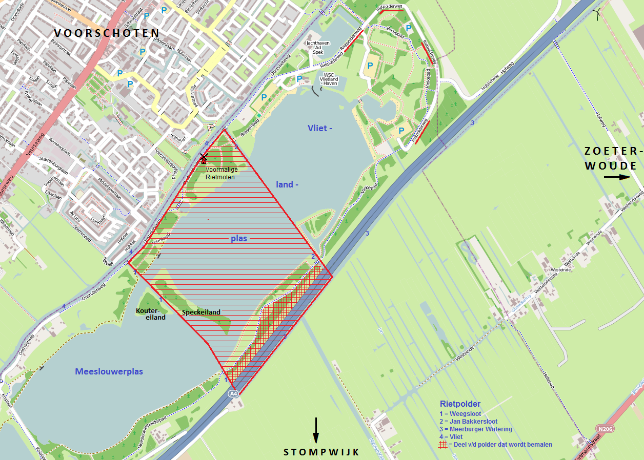
Nederlands: Ligging van de voormalige Rietpolder (rood gearceerd) aan de Vliet in de gemeente Leidschendam-Voorburg, tegenover Voorschoten. Aangegeven is de situatie per nov. 2011. De polder is grotendeels weggebaggerd en is nu een diepe zandafgravingsplas. Aangegeven zijn o.m. de locatie van de voormalige molen, de restanten van de Weegsloot en Jan Bakkersloot die vroeger de 'grens' van de polder vormden, en het deel dat nog bemalen wordt.
English: Location of the former Riet Polder (shaded red) on the river Vliet in the municipality of Leidschendam-Voorburg, opposite the town of Voorschoten (Province of South Holland, Netherlands). Situation shown as of November 2011. Large parts of the polder have been excavated for sand and now form a deep quarry pond. Indicated are the location of the former windmill, the part that is still being drained, and the remains of the two ditches ('sloot') that once formed the boundaries of the polder: the Jan Bakkersloot and the Weegsloot. |
| Date | |
| Source | www.openstreetmap.org, adapted by Loranchet |
| Author | Vincent van Zeijst |
| Permission (Reusing this file) |
The background map is taken from www.openstreetmap.org (which is in the public domain) to which I made some additions. |
The centre of the former Riet Polder is at:
| Camera location | | View this and other nearby images on: OpenStreetMap |
|---|
.png¶ms=052.113728_N_0004.455042_E_globe:Earth_type:camera_region:NL_&language=en)
Licensing
edit.png&action=edit§ion=2)
I, the copyright holder of this work, hereby publish it under the following license:
This file is licensed under the Creative Commons Attribution-Share Alike 3.0 Unported license.
- You are free:
- to share – to copy, distribute and transmit the work
- to remix – to adapt the work
- Under the following conditions:
- attribution – You must give appropriate credit, provide a link to the license, and indicate if changes were made. You may do so in any reasonable manner, but not in any way that suggests the licensor endorses you or your use.
- share alike – If you remix, transform, or build upon the material, you must distribute your contributions under the same or compatible license as the original.
File history
Click on a date/time to view the file as it appeared at that time.
| Date/Time | Thumbnail | Dimensions | User | Comment | |
|---|---|---|---|---|---|
| current | 21:16, 16 November 2011 | | 1,256 × 898 (793 KB) | Loranchet (talk | contribs) | {{Information |Description ={{nl|1=Ligging van de voormalige Rietpolder (rood gearceerd) aan de Vliet in de gemeente Leidschendam-Voorburg, tegenover Voorschoten. Aangegeven is de situatie per nov. 2011. De polder is grotendeels weggebaggerd en is nu e |
You cannot overwrite this file.
File usage on Commons
There are no pages that use this file.
File usage on other wikis
The following other wikis use this file:
- Usage on nl.wikipedia.org
.png&oldid=765983164)