File:New Orleans Aerial view with Gasometers CBD 1921.jpg

Size of this preview: 750 × 600 pixels. Other resolutions: 300 × 240 pixels | 600 × 480 pixels | 960 × 768 pixels | 1,280 × 1,024 pixels.
Original file (1,280 × 1,024 pixels, file size: 477 KB, MIME type: image/jpeg)
Captions
Captions
New Orleans c 1921
Summary edit
| Description |
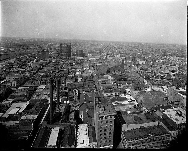
English: New Orleans: Aerial view of section of New Orleans, roughly looking lakewards from around Baronne and Gravier (possibly taken from atop the new Hibernia Building dome), showing the "back of town" part of what is now the Central Business District. Only a few years before part of this area had been the "Black Storyville" quasi-legal red-light district. Also visible are the old Courthouse on Loyola & Tulane Avenues, and the gasometers of the New Orleans Gas Works on Poydras Street. |
| Date | circa 1921 |
| Source | Photo by Charles L. Franck Photographers, via The Historic New Orleans Collection website at [1] |
| Author | Charles L. Franck |
Licensing edit
This work is in the public domain in the United States because it was published (or registered with the U.S. Copyright Office) before January 1, 1929.
Public domain works must be out of copyright in both the United States and in the source country of the work in order to be hosted on the Commons. If the work is not a U.S. work, the file must have an additional copyright tag indicating the copyright status in the source country.
Note: This tag should not be used for sound recordings. |
| Annotations | This image is annotated: View the annotations at Commons |
File history
Click on a date/time to view the file as it appeared at that time.
| Date/Time | Thumbnail | Dimensions | User | Comment | |
|---|---|---|---|---|---|
| current | 18:10, 22 June 2020 | | 1,280 × 1,024 (477 KB) | Infrogmation (talk | contribs) | Uploaded a work by Charles L. Franck from Photo by Charles L. Franck Photographers, via The Historic New Orleans Collection website at [https://www.hnoc.org/virtual/storyville/changing-neighborhood] with UploadWizard |
You cannot overwrite this file.
File usage on Commons
There are no pages that use this file.