File:New Russia on territory of Ukraine.PNG

Size of this preview: 800 × 551 pixels. Other resolutions: 320 × 220 pixels | 640 × 441 pixels | 852 × 587 pixels.
Original file (852 × 587 pixels, file size: 37 KB, MIME type: image/png)
Captions
Captions
Add a one-line explanation of what this file represents
| Description | |
| Date | |
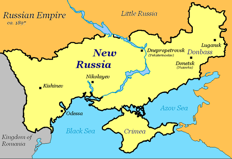
| Source | Self-made map, based off of Image:Map of Ukraine political simple blank.png. |
| Author | Dima Sergiyenko; Please attribute this image as the work of "DiscoverWithDima." |
| Permission (Reusing this file) |
This file is licensed under the Creative Commons Attribution-Share Alike 4.0 International license. Attribution: DiscoverWithDima
|
File history
Click on a date/time to view the file as it appeared at that time.
| Date/Time | Thumbnail | Dimensions | User | Comment | |
|---|---|---|---|---|---|
| current | 20:41, 14 September 2007 | | 852 × 587 (37 KB) | DDima (talk | contribs) | new version |
| 00:32, 20 May 2007 |  | 852 × 587 (34 KB) | DDima (talk | contribs) | Russian Empire and Kingdom Of Romania lables, ca. 1897?? or what year? | |
| 00:11, 20 May 2007 |  | 852 × 587 (30 KB) | DDima (talk | contribs) | Crimea too | |
| 00:10, 20 May 2007 |  | 852 × 587 (30 KB) | DDima (talk | contribs) | colors | |
| 00:06, 20 May 2007 |  | 852 × 587 (29 KB) | DDima (talk | contribs) | Yekaterinoslav and Yuzovka | |
| 23:59, 19 May 2007 |  | 852 × 587 (29 KB) | DDima (talk | contribs) | {{Information |Description={{en|Map of what was called New Russia during the Russian Empire (now southern Ukraine). |Source=Self-made map, based off of Image:Map of Ukraine political simple blank.png. |D |
You cannot overwrite this file.
File usage on Commons
There are no pages that use this file.
File usage on other wikis
The following other wikis use this file:
- Usage on de.wikipedia.org
- Usage on en.wikipedia.org