File:New Zealand transmission grid.svg

Size of this PNG preview of this SVG file: 456 × 599 pixels. Other resolutions: 183 × 240 pixels | 365 × 480 pixels | 585 × 768 pixels | 780 × 1,024 pixels | 1,560 × 2,048 pixels | 524 × 688 pixels.
Original file (SVG file, nominally 524 × 688 pixels, file size: 231 KB)
Captions
Captions
Add a one-line explanation of what this file represents
Summary edit
| Description |
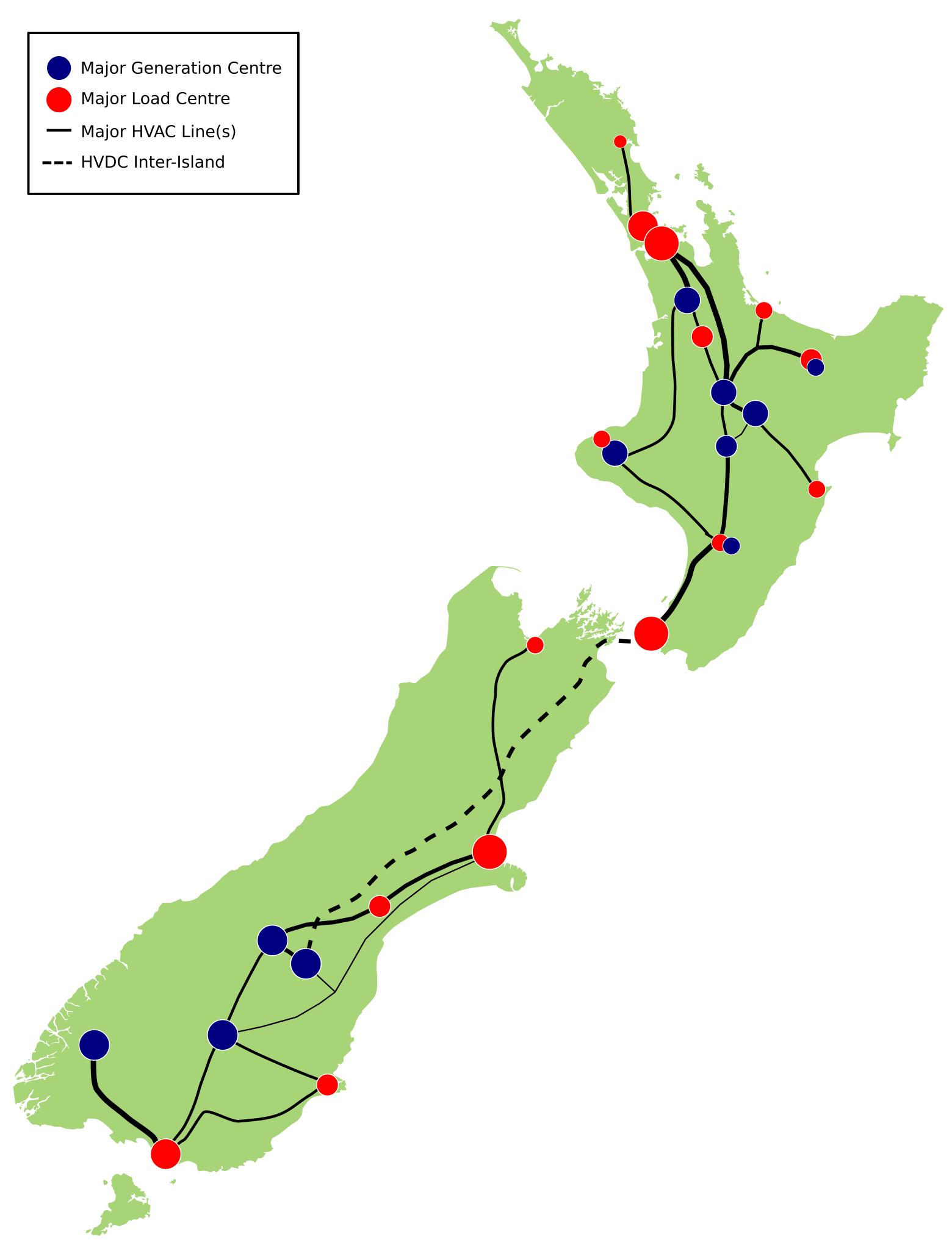
English: A simplified map of the major electricity transmission network in New Zealand, with major generation (blue circles) and load (red circles) centres shown. The solid lines are major 220kV lines or corridors through the country, with the dashed line the HVDC link between the two islands. |
| Date | |
| Source | Based from File:New Zealand locator map blank nobkgnd stdcolours.svg, edited in Inkscape to emulate Generation and Load map at [1] |
| Author | Lcmortensen |
Licensing edit
I, the copyright holder of this work, hereby publish it under the following licenses:
This file is licensed under the Creative Commons Attribution-Share Alike 3.0 Unported license.
- You are free:
- to share – to copy, distribute and transmit the work
- to remix – to adapt the work
- Under the following conditions:
- attribution – You must give appropriate credit, provide a link to the license, and indicate if changes were made. You may do so in any reasonable manner, but not in any way that suggests the licensor endorses you or your use.
- share alike – If you remix, transform, or build upon the material, you must distribute your contributions under the same or compatible license as the original.

|
Permission is granted to copy, distribute and/or modify this document under the terms of the GNU Free Documentation License, Version 1.2 or any later version published by the Free Software Foundation; with no Invariant Sections, no Front-Cover Texts, and no Back-Cover Texts. A copy of the license is included in the section entitled GNU Free Documentation License. |
You may select the license of your choice.
File history
Click on a date/time to view the file as it appeared at that time.
| Date/Time | Thumbnail | Dimensions | User | Comment | |
|---|---|---|---|---|---|
| current | 12:54, 14 September 2018 | | 524 × 688 (231 KB) | Lcmortensen (talk | contribs) | Generation in Auckland gone with Otahuhu/Southdown closure. Add Kawerau as a generation centre. Minor circle size changes. |
| 03:26, 4 May 2012 |  | 524 × 688 (227 KB) | Lcmortensen (talk | contribs) | fix Dunedin to Invercargill line position (south ofGore it parallels Invercargill to Roxburgh) | |
| 02:14, 4 May 2012 |  | 524 × 688 (227 KB) | Lcmortensen (talk | contribs) | modify lines into Auckland and HVDC inter-island | |
| 00:05, 4 May 2012 |  | 524 × 688 (227 KB) | Lcmortensen (talk | contribs) | split Tongariro/Wairakei/Whakamaru and Twizel/Benmore, add Tauranga and South Canterbury load centres, North Island Grid Upgrade and split Christchurch-Roxburgh lines, plus tweaking on circle sizes and line thicknesses. | |
| 07:06, 21 June 2009 |  | 524 × 688 (223 KB) | Lcmortensen (talk | contribs) | tweak locations in Taranaki and Bay of Plenty | |
| 22:45, 7 May 2009 |  | 524 × 688 (223 KB) | Lcmortensen (talk | contribs) | {{Information |Description={{en|1=A simplified map of the major electricity transmission network in New Zealand, with major generation (blue circles) and load (red circles) centres shown. The solid lines are major 220kV lines or corridors through the coun |
You cannot overwrite this file.
File usage on Commons
There are no pages that use this file.
File usage on other wikis
The following other wikis use this file:
- Usage on de.wikipedia.org
- Usage on en.wikipedia.org
- Usage on fr.wikipedia.org
- Usage on www.wikidata.org